Pumping Tuesday, average Wednesday then great again Thursday
Victoria Forecast by Craig Brokensha (issued Monday 25th July)
Best Days: Experienced surfers Surf Coast Tuesday, later Wednesday Surf Coast, Thursday and Friday Surf Coast, Saturday both coasts, Sunday Surf Coast
Recap
Saturday was wild and wooly with a large building W/SW swell along with strong winds from the western quadrant. Protected locations offered workable waves into the mid-late afternoon.
Sunday saw excellent conditions across the Surf Coast with solid easing sets to 4-5ft under offshore winds, and fun waves in Western Port early.
Into the afternoon a reinforcing and less consistent SW groundswell filled in, and this has kept 3ft sets hitting the coast into this morning under a fresh and gusty NW breeze. We can expect the surf to ease through the day as winds strengthen from the W/NW.
This week (Jul 26 - 29)
As talked about last week, we've got a very active week of surf ahead, and tomorrow's increase in W/SW swell has been upgraded in size since Friday.
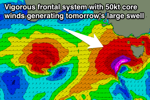
 Over the weekend a vigorous polar low formed in the Heard Island region, projecting a fetch of severe-gale to storm-force W/SW winds towards us (right). This low has since taken the form of a frontal system south of WA, with a fetch of severe-gale W/SW winds forecast to be projected towards us through today, pushing across us this evening.
Stronger core winds to the storm-force range are likely just off Tassie this afternoon and evening, helping to generate a large, powerful and dangerous W/SW groundswell.
This swell will fill in tomorrow, large from dawn and peak through the middle of the day with 6-8ft sets due on the Surf Coast and 10ft+ waves on the Mornington Peninsula. This swell will only be for the most experienced surfers.
The swell will ease back through Wednesday, but the longer-period energy from the early stages of the low will keep large surf hitting both coasts through the morning, easing back into the afternoon and further Thursday.
The Surf Coast should ease back from 5-6ft with 8ft sets on the Mornington Peninsula smaller into Thursday.
Conditions over the coming period will be best on the Surf Coast Tuesday and Thursday with a W/NW tending N/NW breeze due tomorrow, poor SW winds moving through dawn Wednesday (possibly tending W/NW later in the day) and then persistent W/NW winds Thursday.
 Into the end of the week and weekend moderate amounts of W/SW swell are expected from persistent but weaker mid-latitude frontal activity moving under the country and stalling across Tassie into the end of the week.
The first pulse should build Friday afternoon, holding Saturday to an inconsistent 3ft to occasionally 4ft at swell magnets on the Surf Coast and 6ft on the Mornington Peninsula.
Winds will persist from the W/NW Friday, with more favourable N/NW tending light N/NE winds east of Melbourne Saturday.
Longer term smaller surf with N/NW winds is expected Sunday and into early next week, with a strong long-period W/SW groundswell on the cards from Tuesday, but more on this in the next update.


Comments
Some good snow totals due off this system as well across the mountains.
Craig is the swell direction more west or south?
More west.
Solid set in the Bowl yesterday..