Good swells with OK winds, cleaner and easing over the weekend - large next week
Victoria Forecast by Craig Brokensha (issued Wednesday 6th July)
Best Days: Surf Coast early Thursday morning, both coasts Friday, Surf Coast Saturday morning, to the east into the afternoon and then Sunday morning, Surf Coast from Tuesday
Recap
A limited window of clean conditions mainly west of Barwon Heads yesterday morning with fresh onshores from there to the east. Torquay was the best bet with workable 3ft sets before the change kicked in mid-morning.
Today conditions were a write-off with a mix of windswell and groundswell along with gusty onshore winds.
This week and weekend (Jul 7 - 10)
Our two pulses of SW and S/SW groundswell due tomorrow and Friday respectively are still on track and winds are now looking better into Friday.
The first pulse tomorrow morning will be a mix of long-range and inconsistent SW groundswell along with some slightly more consistent S/SW energy.
 The models seem to be over-forecasting the size of these swells, with infrequent 3ft+ waves due on the Surf Coast along with 5-6ft sets on the Mornington Peninsula.
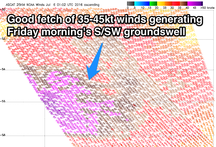
Friday's swell will be more consistent and from the S/SW, generated by a polar fetch of gale to severe-gale W'ly winds.
Again good 3ft+ waves are due on the Surf Coast (4ft sets likely swell magnets through the morning) with 5-6ft sets on the Mornington Peninsula. A drop in size is then expected through the day and further Saturday from 2-3ft and 4-5ft respectively.
Now, winds are still touch and go for tomorrow. Variable winds are likely early on the Surf Coast but to the east, SE-E/SE winds are due to be blowing, making their way west through the day.
Friday will then be a tricky one, but the take home message is that the dawny will likely be lumpy and not the best.
An early variable breeze is due to swing more locally offshore through the morning across both coasts and then likely SW into the afternoon.
As the swell eases through the weekend, light NW tending variable winds will favour the Surf Coast through the morning and Mornington Peninsula into the afternoon.
Our new acute W/SW groundswell has been wiped off the charts unfortunately, with the low that was expected to generate it south of WA now just remaining as a surface trough, with no fetch aimed towards us at all.
Instead the Surf Coast will become small to tiny, while the Mornington Peninsula will be the pick with easing 3ft sets and strengthening N/NE winds.
Next week onwards (Jul 11 onwards)
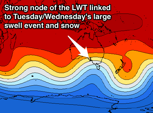
 Monday morning will start tiny with a fresh and gusty N/NW'ly, but a very strong cold outbreak will strengthen to our west during the day and start moving east across us through Tuesday.
This will be result of a strengthening node of the Long Wave Trough across the south-east of the country early next week.
With this we'll see a large groundswell event through Tuesday and Wednesday along with some good snow falls.
Through Sunday and Monday a vigorous mid-latitude low will develop and push through the Bight, under the influence of the LWT, but we won't see any fetches aligned within our swell window until Monday morning. With this tiny surf is due most of Monday ahead of a late kick in acute W'ly swell but to no major size.
It will be more so Tuesday and Wednesday when we see the surf really jump as a broad and elongated fetch of gale to severe-gale SW winds extending all the way to the ice shelf are aimed through our swell window.
This will generate a large building W/SW tending SW groundswell through Tuesday, more so the afternoon, and then peaking Wednesday morning.
Size wise we're probably looking at surf in the 6-8ft range during its peak on the Surf Coast and 10ft+ on the Mornington Peninsula along with strong W/NW-SW winds. We'll have a closer look at this Friday though.


Comments
Hi Craig,
thanks for the report.
Do you think there is enough swell there for the east coast on the weekend - Kilcunda through to Cape Liptrap?
It will be a touch smaller than the Mornington Peninsula, probably easing 3-4ft Saturday and 2ft+ Sunday.
thanks mate most appreciated
Any scientific reasoning that when there is a forecast period of good days i.e mondays notes for the weekend, that the good days always seem to disappear instead of perhaps increasing. Like a 2 period increasing to 3-4 days rather than 2 days becoming not even one good day?
Hey nick Bone head, have a think about your comment mate and draw your own conclusions. Look at what the forecast has said and,what has been forecast. There may be reasons as to why it has changed .Look at the maps and data and then learn when it will be best.
Peace out man.
Hey buddy. Funnily enough im actually trying to read and understand synoptics and what not. But being a beginner, a question a couldnt work out a answer for came albeit a bit off topic and i thought i might be able to ask someone with far more experience. I know now this is not the route to take. Sorry i have upset you here brainiac, but perhaps you could impart some of your wisdom onto a rather harmless question?
Cheers
Brainiac eh...
Different name, same knob gobbler
Hey goofy , no mate , not a different name , or same gobbler. Just someone of the same vintage as you, who looks at our worlds ' and goes what the fuck is going on? Part of the problem is people been spoon fed information, and lack the ability to think and make decisions for themselves! Nick that's great learning and trying to understand and I hope you get more waves from it. The point I am making is that I may be right or wrong , but in the Vicco notes, I have noticed a little more subtlety in the forecasts and as a result the crowds have been reduced on days still with good waves. I hope it continues.Maybe I am just getting better at picking times and spots to avoid crowds, but I certainly am loving winter. I hope you all are getting your fill.
So you're not the artist formerly known as victoriasurfing1 ? I apologise if that's not the case..
No sweat goofy!
Good days are subjective, and my good days which I try and cater for most surfers, may not be so good for other people.
The reason Sunday changed was becaused the new W/SW swell disappeared.
Not having a crack at the forecast at all. Just wondering aloud as too why good days/conditions forecasted down the track always seem to deteriorate rather than improve/expand. My take is just that good condtitions need the stars to align as it is so for a growing period of good conditions rather than not the stars would have the align even more so to speak.
Hey Craig,
The models have a 2.5m N swell peaking Monday but you're calling this is the low point of swell everywhere ... Will this Nly swell contribute to swell anywhere ? What is its source ?
Thanks for your time
I understand that it's out of the swell window for places on the Surfcoast ... but would the open SW facing coasts feel it ? If there was a massive Nly swell would we feel a little bit of it kinda like when we get a W swell on the Surfcoast?
N'ly swell won't get in anywhere, if more NE, maybe Apollo Bay/Lorne but I'd be looking at that other piece of land across Bass Strait.
thanks craig (:
I think that just comes from howling N winds and the buoys misinterpret that.
The virtual buoys are offshore. The Northerly swell is there, but it is traveling away from the coast. The buoys aren't misinterpreting that. You are misinterpreting the buoys. Simples.
This is true.
Strong northerly winds have a significant downward projection and tend to 'push' down on the trough between waves. This increases the height of the waves relative to the height of the trough even though the crest of the wave remains at the same height . On the other hand, strong southerlies tend to have an upward projection and therefore 'pull' the crest of the waves upwards while the trough remains at the same height. Some breaks such as Winki and Bells are suited to 'pull' swells, while north east swell magnets such as Lorne and Apollo Bay prefer the 'push' swells. This may go unnoticed to the untrained eye, however those of us who are onto surfing the rare north easterly swells keep a keen eye on these details which you won't see in the weekly Swellnet forecasts.
A north swell in Victoria eh ?
get on a mat and ride to tassie !! no wave too fat
You never know Caml
Thats right some of the coast faces north ?
You've gotta think outside the square sometimes caml, you used to but now you don't, your showing your age ;)
chompin at the bit at the moment, seaspray is looking good with an east swell and the wind switching to the NW some time in the morning ;)
Thanks for the advice