Good run for the Surf Coast
Victoria Forecast by Craig Brokensha (issued Friday 1st July)
Best Days: Surf Coast Saturday, Sunday, Monday and early Tuesday, east of Melbourne Monday and early Tuesday
Recap
Fading swell under fresh and gusty offshore winds yesterday, becoming tiny into the afternoon. This morning a short-range W/SW swell is on the build with bumpy 2-3ft sets on the Surf Coast with a W/SW winds and messier 5-6ft sets on the Mornington Peninsula beaches.
A stronger long-range W/SW groundswell is due this afternoon to 3-4ft on the Surf Coast and 6ft+ on the Mornington Peninsula as winds tend more W/NW. This is now showing on the Cape Sorell buoy, with hints on the Point Nepean buoy. So an arvo surf west of Melbourne is more than on the menu.
This weekend and next week (Jul 2 - 8)
The weekend is looking excellent for the Surf Coast with lots of swell and persistent offshore winds.
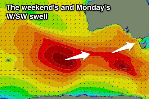
 This afternoon's long-range swell will be replaced by a better and more consistent W/SW groundswell from a broad fetch of pre-frontal W/NW gales moving under the country the last few days.
Good 3-4ft sets are due across most locations under a fresh W/NW wind, with larger bumpier 6ft+ sets to the east.
A drop in size is due through Sunday from 3ft+ on the Surf Coast and 5-6ft on the Mornington Peninsula as winds swing NW and persist all day.
Monday morning will likely start off a little slow as we fall in between swells with 2-3ft sets on the Surf Coast and waves to 5ft on the Mornington Peninsula.
Our new inconsistent and long-range W/SW groundswell due for the afternoon is still on track, with this swell due to be pretty similar to the one expected this afternoon.
Inconsistent 3-4ft sets are due to develop on the Surf Coast with 6ft+ waves to the east under better N/NW tending N'ly winds on the Mornington Peninsula (N/NW most of the day Surf Coast).
An onshore change linked to a surface trough moving in from the west has now been moved back to Tuesday.
This trough is forecast to take the form of a deepening mid-latitude low, with variable winds dawn Tuesday before it starts moving across us during the day, bringing freshening SE winds. This will be with easing amounts of W/SW groundswell from Monday.
A poor S/SE windswell will be generated by the low along with gusty but easing S'ly winds Wednesday, improving into Thursday.
Longer term, favourable winds from the northern quadrant along with fun amounts of swell is likely into next weekend, but more on this Monday. Have a great weekend!

