Average end to the week, great weekend
Victoria Forecast by Craig Brokensha (issued Wednesday 29th June)
Best Days: Keen surfers tomorrow with tricky offshores, Friday afternoon Surf Coast, Surf Coast Saturday and Sunday, possibly Surf Coast early Monday
Recap
Good but inconsistent 3-4ft waves on the Surf Coast yesterday, with a better stronger and more consistent W/SW swell to 3-5ft this morning.
This week and weekend (Jun 30 – Jul 3)
Short summary today as I'm not feeling the best.
Strong N'ly winds will create tricky surfing conditions tomorrow as today's W'ly swell fades away from 2ft+ on the Surf Coast and 3-4ft+ on the Mornington Peninsula. Winds will swing NW through the afternoon so hit locations east of Melbourne through the morning.
Our mix of swells for Friday are still on track but conditions are now looking poor with a fresh to strong SW'ly due to be in from dawn. Winds will swing more W/SW through the day and the late session on the Surf Coast may be OK. A short-range W/SW swell is due to offer 3-4ft sets on the Surf Coast, with a groundswell for the afternoon to a similar size.
The weekend is looking much better with a couple of reinforcing W/SW groundswells from broad pre-frontal fetches of W/NW gales moving under the country over the coming days.
Conditions will be best on the Surf Coast with a W/NW offshore Saturday and 3-4ft sets, and then NW winds Sunday as the swell drops a touch to 3ft+. The Mornington Peninsula won't offer too many options besides the odd small wave in Western Port Saturday.
Next week onwards (Jul 4 onwards)
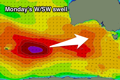
 A good long-range W/SW groundswell is due Monday from a strong and long-lived polar low firing up in the Heard Island region. We're probably looking at inconsistent 3-4ft+ sets on the Surf Coast with 6ft+ waves on the Mornington Peninsula, but winds are an issue with a weak surface trough moving through around dawn, with a developing S/SE'ly due. We'll look at the timing of this closer Friday.
A drop in size is due Tuesday with more variable winds, but more on this Friday.


Comments
Bring on the SE
Thx Craig for the written reports, always appreciated and a point of difference that Swellnet has.
No worries VJ, looked like I pushed myself a little hard out in the mountains over the weekend!
Update: Winds are now looking better for the Surf Coast Friday.
There's a good chance for an early W'ly wind around Torquay, but regardless, winds should tend W/NW mid-late afternoon so the late session will be good.
Hi Craig,
thanks a lot for the forecast and update. I was wondering whether you had any insights as to the swell next weekend (9th / 10th) the forecast winds are tending NE so i was thinking about heading far east (cape liptrap - sandy point) if there is enough swell!!
Cheers
Gus
Likely to move around with some funky cut-offs in the region but at this stage it's looking N'ly Saturday.
"Short summary toady as I'm not feeling the best." I love it how you have personlised this forecast and given us a pet name ;)
Haha, fixed!
Thanks Craig thats awesome, really appreciate the update!
I'll look forward to your next update and hope you get better soon!!
Love your work Craig, get better soon mate