Fun couple of days ahead
Victoria Forecast by Craig Brokensha (issued Monday 27th June)
Best Days: Surf Coast Tuesday, Wednesday (east of Melbourne Wednesday afternoon), protected spots out of the wind Thursday morning, Surf Coast Friday, Saturday and Sunday
Recap
Workable waves on the Surf Coast Saturday but nor perfect with easing and slightly bumpy 3-4ft sets, improving into the afternoon as winds remained light and tended offshore late.
Sunday was cleaner but smaller, coming in around 2-3ft most of the day on the Surf Coast, while the Mornington Peninsula was average most of the weekend.
Today some short-range W/SW swell has kept 2-3ft sets hitting the Surf Coast, but a strong long-range and inconsistent W/SW groundswell is due into the afternoon. This is just showing on the Cape Sorell wave buoy, but with no major increase in size. With a travel time of 3-4 hours, we'll probably only see this swell kick late afternoon now besides mid-afternoon, and the readings off South Australia indicate that it may be a touch smaller than forecast Friday. Winds will remain good for the Surf Coast though, so the late will be the go.
This week (Jun 28 – Jul 1)
Late this afternoon's increase in long-range W/SW groundswell is expected to peak overnight and then ease off through tomorrow, but we should still see good clean 3-5ft sets at swell magnets on the Surf Coast and 6ft+ sets on the Mornington Peninsula as a NW breeze favours locations west of Melbourne.
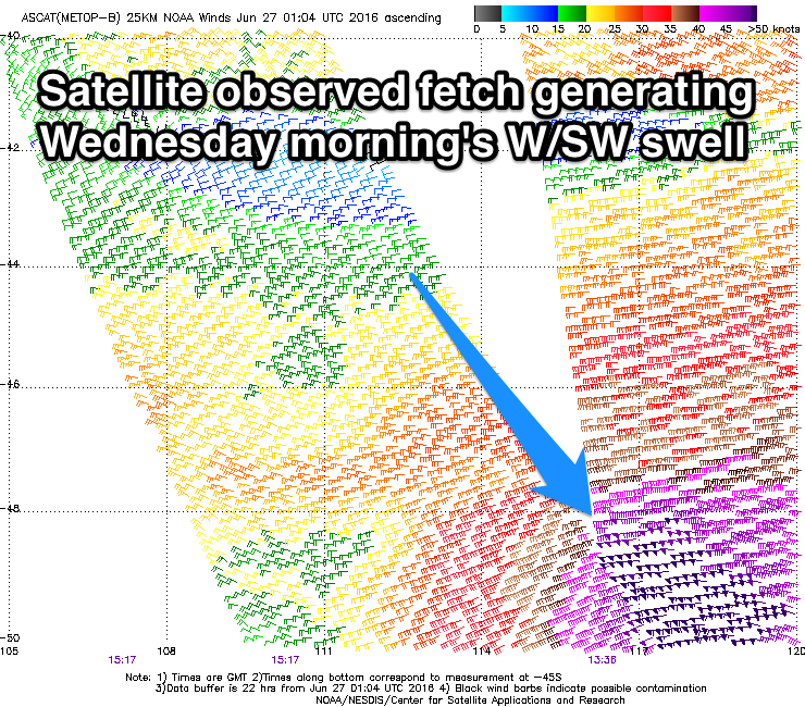
 Into Wednesday a new pulse of moderate sized W/SW groundswell is due, generated by a tight but intense mid-latitude low currently moving towards us.
Satellite observations have picked up storm-force W'ly winds through our western swell window, south of WA, with the low now weakening while approaching Tasmania.
Size wise we should see good 3-4ft sets on the Surf Coast Wednesday morning with 6ft+ sets on the Mornington Peninsula, easing through the day. Conditions will improve across locations east of Melbourne and deteriorate at selected spots to the west with a moderate to fresh NW tending N'ly breeze.
Thursday will see the swell really drop away with fading 2ft+ waves on the Surf Coast and 3-5ft sets on the Mornington Peninsula with strong and tricky N'ly winds ahead of a W'ly change.
Friday looks tricky with a mix of building long-range W/SW groundswell and localised windswell from the front generating the groundswell pushing in and across us.
The long-range energy is already being generated by a distant polar low firing up in the Heard Island region, with a fetch of pre and post-front gale to severe-gale winds producing an inconsistent 3-4ft of groundswell for the Surf Coast Friday afternoon and 6ft+ on the Mornington Peninsula.
For the morning though some short-range W'ly swell from the front is likely to come in around 3ft on the Surf Coast and 5-6ft on the Mornington Peninsula but with lower quality.
Winds at this stage look to be mainly from the W but we'll have another look at this Wednesday.
Into the weekend a much better and more consistent reinforcing W/SW groundswell is due Saturday from a good fetch of pre-frontal W/NW gales moving in post Friday's front, with both coasts due to continue around a similar size to Friday afternoon, easing a touch Sunday with favourable W/NW winds.
Longer term a strong cold-outbreak and large swell are likely Monday, but more on this in the next update.


Comments
Hey Craig I'm trying to find some historical swell data going back too 2014 for a project. Do you know any links that will have this data for Victoria? Cheers
Contacting the BOM would be the best for that if looking at Cape Sorell data or if it's over a single swell event/short space of time, send an email to info@swellnet.com and we may be able to help. Cheers