Lots of swell over the weekend, best Sunday morning
Victoria Forecast by Craig Brokensha (issued Friday 17th June)
Best Days: Both coasts Sunday morning, Tuesday morning Surf Coast, Wednesday morning Surf Coast, Thursday both coasts
Recap
Good clean 3-4ft waves across the Surf Coast yesterday morning and up to 5-6ft to the east, while a strong new S/SW groundswell filled in through the afternoon as winds remained favourable from the N'th. The Surf Coast saw easy 5ft sets with larger bombs on the Mornington Peninsula.
This morning the swell was still around a strong and pumping 4-5ft on the Surf Coast and 6-8ft on the Mornington Peninsula with a light offshore wind. The change due through the morning has now been delayed and it's only due to arrive late afternoon/evening now, so get amongst it!
This weekend and next week (Jun 18 - 24)
Our large strong S/SW groundswell seen yesterday and this morning will ease into this afternoon and further tomorrow only to be replaced by a moderate sized mid-period SW swell.
The only issue is that with today's onshore change delayed to later this afternoon, we'll see winds linger onshore into tomorrow morning across all regions from the S/SW, tending lighter S/SE through the day. This will create average but improving conditions.
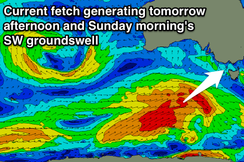
 The SW swell pulses due over the weekend, one for tomorrow morning and another for the afternoon produced by a couple of back to back polar fronts under the country the last couple of days.
The front linked to later Saturday/Sunday's pulse is still generating a great fetch of W/SW gales through our swell window to our south-west with a slight upgrade in size expected later tomorrow and Sunday morning.
Building surf to 3-5ft and 6-8ft is expected on the Surf Coast and Mornington Peninsula respectively tomorrow afternoon, easing back form a similar size Sunday morning.
Conditions are looking better Sunday morning but still probably lumpy from overnight onshores, with a light variable wind due across both coasts, tending S'ly through the day.
Into Monday the swell will continue to ease but still be around 3ft on the Surf Coast and 5-6ft on the Mornington Peninsula with less favourable S/SW winds due to move in. There's a chance for variable winds again during the morning, but keep an eye on local observations for this.
When the swell eased back further Tuesday, gusty N/NW tending W/SW winds will limit options a little with small 2ft+ sets on the Surf Coast and bumpy 3-4ft+ waves on the Mornington Peninsula.
With Tuesday afternoon's change we're due to see a moderate sized increase in short-range W/SW swell for Wednesday, followed by a stronger inconsistent SW groundswell through Thursday afternoon from earlier incarnations of the low.
A stronger cold outbreak is due later in the week, and then following this a larger long-period W/SW groundswell for Monday week, but more on all of this Monday. Have a great weekend!


Comments
Pumping waves on offer this afternoon. Clean and solid.
my impression was Thursday had the size/length of lines/more consistent? Oh well, none of us can complain ;)
Yep I'd agree with that. What a great week!
Yes t did Johnno :)
Wams are looking pretty good next Friday Craig looks onshore but nice big swell maybe like that swell during bells comp 6ft+ do you reckon Craig ?
Our surfcams take random snaps every five minutes. How's this one of old mate banking it off the top at Lorne! I am impressed.
Looking super fun in Torquay this morning.