Strong powerful S/SW swell filling in tomorrow afternoon
Victoria Forecast by Craig Brokensha (issued Wednesday 15th June)
Best Days: Both coasts tomorrow, Surf Coast Friday morning and Saturday morning
Recap
Great waves all day yesterday across the Surf Coast with the swell coming in around 3-4ft for the most part with 5ft sets at times across swell magnets. Offshore winds tended lighter from the W keeping conditions clean on the reefs. Protected locations were the pick east of Melbourne.
This morning great 3-5ft waves are continuing across the Surf Coast with another pulse of SW groundswell, but this will ease through the day. The Mornington Peninsula was large and clean with 6ft+ sets, better in more protected spots and on the reefs.
This week and weekend (Jun 16 - 19)
This morning's reinforcing SW groundswell is already easing back on the Cape Sorell wave buoy and we'll see this trend across the beach through today.
The swell will continue to ease into tomorrow morning, but not drop below 3ft on the Surf Coast and 4-6ft on the Mornington Peninsula beaches.
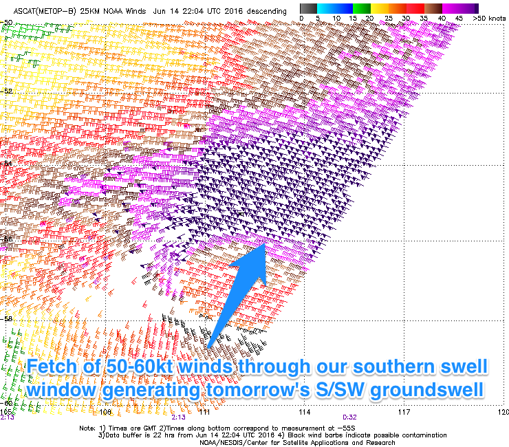
 Our strong, powerful long-period S/SW groundswell due to arrive through the late morning is still on track with satellite observations picking up a very impressive fetch of storm-force 50-60kt winds through our southern swell window.
We should see the swell build rapidly and noticeably once it arrives with the Surf Coast swell magnets that rake in these long-period S/SW swells due to reach an easy 4-5ft+ and 6-8ft on the Mornington Peninsula through the mid-late afternoon.
A peak is due overnight, with the swell easing back from 3-5ft and 6ft+ respectively Friday morning.
Winds are looking to be more N'ly than NW most of tomorrow and this will favour both coasts, but the Torquay reefs will likely be bumpy especially with the fresh nature of the offshores.
Into Friday morning an early NW'ly is due, giving into a gusty S/SW change late morning.
Into the weekend a couple of reinforcing SW groundswell pulses are due from weaker but back to back polar fronts firing up under WA and then pushing towards us over the coming days.
The first pulse is due Saturday morning ahead of a slightly stronger increase later in the day, easing slowly Sunday.
The Surf Coast should offer 3ft to occasionally 4ft waves most of Saturday, possibly the odd bigger one later in the day, with 5-6ft sets on the Mornington Peninsula.
Easing surf from 3-4ft (possibly odd bigger one early) and 6ft respectively Sunday morning.
Conditions on Saturday morning are expected to be lumpy and not perfect after Friday's change, with onshore S/SW tending S/SE winds across the Mornington Peninsula, while the Torquay region is likely to see a morning W/NW'ly.
Sunday isn't looking too much better with an E/SE onshore breeze (possibly E/NE on the Mornington Peninsula) but we'll review this Friday.
Next weekend onwards (Jun 20 onwards)
It looks like another intense low forming off the Australian East Coast will continue to direct E/SE onshores into our coasts Monday as the swell eases, swinging back offshore into Tuesday once the low continues tracking south-east.
Surf wise there's nothing too significant due, so make the most of the coming days.


Comments
In saying that with the E/SE winds over the weekend, there isnt to much strength to them?
Tricky to say at this stage, but likely moderate to fresh early Sunday, easing through the morning.
Just when we need it, Cape Sorell hasn't updated since 7:20am this morning!
The new S/SW groundswell is kicking strongly now..