Good Sunday, excellent run next week
Victoria Forecast by Craig Brokensha (issued Friday 10th June)
Best Days: Early Saturday morning Surf Coast, Sunday Surf Coast, both coasts all next week
Recap
Good clean easing groundswell from 3ft on the sets across the Surf Coast yesterday, bumpy and a bit bigger on the Mornington Peninsula.
Today some new mid-period SW swell has come up today, a little unexpected with clean fun 2-3ft waves on the Surf Coast and workable 4ft+ sets on the Mornington Peninsula under N/NW winds. Conditions should remain clean on the Surf Coast most of the day ahead of a late afternoon onshore change.
This weekend and next week (Jun 11 - 17)
More size is now due into tomorrow across the state as the strengthening polar front projecting up and into us packs a touch more punch than forecast Wednesday.
Currently a pre-frontal fetch of W/SW gales are projecting towards us, pushing through Bass Strait early tomorrow morning resulting in a moderate to large sized increase in SW swell through the day.
The morning now looks to be around 2-3ft on the Surf Coast and 5ft on the Mornington Peninsula, building to 4-5ft and 6-8ft respectively later in the day across both coasts.
Conditions will only be good for a short period early on the Surf Coast with an early W/NW'ly, tending fresh to strong SW mid-morning.
Into Sunday trailing fetches of SW winds through our southern swell window will continue to produce moderate sized S/SW swell, easing back from 3-5ft on the Surf Coast and 6ft to occasionally 8ft on the Mornington Peninsula.
Conditions will improve and be best west of Melbourne with a W/NW-NW breeze persisting all day.
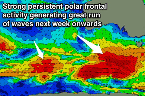
Into next week, our great run of waves is still shaping up.
We'll see a flurry of strong polar frontal activity from tomorrow through most of next week.
 Initially tomorrow a pre-frontal fetch of W/NW gales will generate a steadying SW groundswell for Monday afternoon with the Surf Coast not likely to drop below 3ft+ and 5-6ft on the Mornington Peninsula.
Stronger severe-gale W/NW to W/SW fetches should then generate a larger pulse of SW groundswell for Tuesday afternoon and Wednesday. The Surf Coast should see solid 3-5ft sets with 6ft to occasionally 8ft waves on the Mornington Peninsula Tuesday afternoon and Wednesday morning, easing back slightly into the afternoon and further into Thursday.
Offshore N/NW winds are due through the entire period as a large and slow moving high pressure system sits just to our east. The Mornington Peninsula should also see even better N'ly winds at times through most of next week.
Strong polar frontal activity will continue through next week, with additional long-period SW groundswell pulses due Thursday/Friday and into next weekend, but more on this Monday. Have a great weekend!


Comments
Not looking too shabby at 13th Beach this morning.