Surf Coast continues to provide
Victoria Forecast by Craig Brokensha (issued Friday 13th May)
Best Days: Surf Coast every day, selected spots east of Melbourne Saturday morning and Monday
Recap
Excellent waves across the Surf Coast yesterday with a strong reinforcing swell to 4-6ft across the reefs with an all day offshore breeze. The Mornington Peninsula was too large, with Western Port and other protected breaks fairing the best.
Today the swell is still up around the same size with a moderate offshore wind for the Surf Coast, but we'll see the swell ease through the day as winds remain offshore.
This weekend and next week (May 14 - 20)
The frontal system responsible for our current swell has moved out of our swell window and with this we'll see wave heights drop away through this afternoon, further down tomorrow to 3-4ft on the Surf Coast. The Mornington Peninsula should be in the 6ft+ range.
A slight kick in reinforcing swell is due through the afternoon though from a strong but small fetch of gale to severe-gale W'ly winds through our south-western swell window today.
This should keep 3-4ft waves hitting the Surf Coast with the odd bigger set possible at times at swell magnets, with 6ft to sometimes 8ft sets on the Mornington Peninsula.
A drop in size is then due into Sunday from 3ft+ and 6ft respectively.
Conditions will be great all day tomorrow with a moderate and freshening N/NW tending NW breeze, with NW tending W/NW winds Sunday ahead of a mid-late afternoon W/SW change.
Into next week, our long-period and long-range W/SW groundswell is still on track, with it due to build through Monday and peak into the afternoon.
The morning is likely to be around 2-3ft on the Surf Coast and 5-6ft on the Mornington Peninsula, building to an inconsistent 3-4ft and 6ft to occasionally 8ft respectively into the afternoon.
Monday will see offshore N/NW winds persist most of the day, opening up plenty of options.
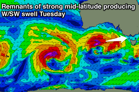
 Now into Tuesday strong long-period but acute W'ly groundswell is due into the afternoon, generated by a very strong and powerful mid-latitude low firing up under WA this weekend. A fetch of severe-gale to storm-force W/SW winds will be produced through our westerly swell window, with the system continuing east and pushing through Bass Strait Tuesday.
A moderate to large W/SW groundswell will be generated by the front pushing into us Tuesday morning, with the groundswell arriving through the late afternoon, easing Wednesday.
The Surf Coast should see 3-5ft waves Tuesday morning, easing later, with 6-8ft sets on the Mornington Peninsula. Gusty W/NW winds will favour the Surf Coast over the Mornington Peninsula, with NW winds Wednesday as the surf continues to ease.
Another couple of strong mid-latitude fronts are due to move through our swell window next week, generating additional pulses of W/SW swell from Thursday afternoon, but more on this Monday. Have a great weekend!


Comments
The surf coast forecast models are hopefully undercalling a little bit?
Yeah with the weekend's W/SW swells it looks so.
nice