Average weekend, solid Sunday, clean and easing next week
Victoria Forecast by Craig Brokensha (issued Friday 15th April)
Best Days: Protected spots Sunday, both coasts Monday morning, Tuesday morning, east of Melbourne Wednesday and Thursday morning
Recap
A new inconsistent SW groundswell filled in yesterday, and the Mornington Peninsula performed the best with sets between 4-6ft, while 13th Beach and Fairhaven were best on the Surf Coast with infrequent 3ft sets.
This morning conditions were much cleaner and straighter across all locations with a drop in swell back to 2ft on the Surf Coast and the 4ft range on the Mornington Peninsula.
This weekend and next week (Apr 16 – 22)
The weekend isn't looking flash at all, with a gusty onshore change due around dawn tomorrow as the swell bottoms out. Into the mid-late afternoon some new SW groundswell is due from a strong frontal progression taking place to our south-west.
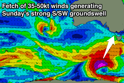
 While a late kick in size is due tomorrow, the largest increase in size is due through Sunday, as a result of the polar frontal progression strengthening today, aiming a great fetch of severe-gale to storm force SW winds through our southern swell window.
The size from this swell has been upgraded a touch due to the stronger storm-force core winds, with the Surf Coast due to peak during the afternoon around 4-5ft, with 6ft sets likely at Bells and Winki, while the Mornington Peninsula is due to see 6-8ft sets.
Conditions will remain poor though with a fresh and gusty S/SE breeze.
Monday is the day to surf, as an approaching trough through the Bight pushes a small high across us, swinging winds offshore from the N/NE (possibly N/NW on the Surf Coast later morning) before sea breezes kick in.
There should still be plenty of size on offer with easing 3-4ft waves on the Surf Coast (possible bigger bombs swell magnets) and 6ft sets on the Mornington Peninsula.
Tuesday looks great as well with local offshore winds and a further drop in size.
The swell is due to bottom out through Wednesday and with morning N'ly winds, the Mornington Peninsula will be the best option with infrequent but fading 2-3ft sets.
A very inconsistent long-range SW groundswell is due Thursday but with no major size across both coasts. The Surf Coast may see the odd 2ft set, with 3ft to occasionally 4ft waves on the Mornington Peninsula and conditions will remain favourable with morning offshores ahead of a shallow afternoon S/SW change.
Longer term the outlook remains less than ideal with a large blocking high deflecting away any major frontal activity. We'll then have to rely on long-range and inconsistent swells, with one due next weekend. We'll have a closer look at this Monday. Have a great weekend!


Comments
Another big swell over the weekend due that's like 3 weeks in row but the best conditions due during the week still the weekend warrior could have a good winter again this year
Yeah you're right, weather patterns changing from next week though.