Plenty of swell to come with strengthening onshore winds
Victoria Forecast by Craig Brokensha (issued Friday 11th March)
Best Days: No decent days until Thursday next week
Recap

Yesterday started off relatively small and onshore but conditions improved across all locations through the day as winds tended more variable and a strong increase in SW groundswell filled in.
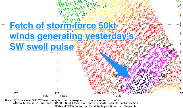
This swell jumped above expectations and the reason is to your right. Wind speeds within the intense mid-latitude low generating the swell were only forecast to be gale-force, but satellite observations show storm-force 50kt core winds, leading to the large strong spike in size.
The short-lived nature of the low saw the swell follow a similar pattern, with the surf easing back from 3ft on the Surf Coast and 5ft on the Mornington Peninsula this morning under variable winds.
This weekend (Mar 12 - 13)
The weekend isn't looking too flash, with the surf due to ease further into tomorrow, with small leftover and fading 2ft sets on the Surf Coast, and 3-4ft waves on the Mornington Peninsula. Conditions will be workable though with a light to moderate S'ly at dawn, freshening through the day.
Sunday's building long-range and inconsistent SW groundswell is still tracking along well, with the frontal progression generating this swell in a much weakened and dissolved state south of WA.
The swell should build gradually through Sunday, reaching an infrequent 3ft+ into the afternoon on the Surf Coast and 6ft across the Mornington Peninsula. Winds are still looking dicey with a moderate S/SE breeze, freshening through the day as the swell starts to show size.
Next week onwards (Mar 14 onwards)
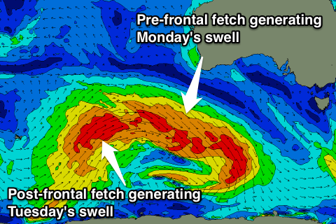
 Sunday's swell should ease back through Monday morning with poor conditions under a strengthening onshore S'ly wind. This will also spoil a good new SW groundswell due to fill in through the day, generated by a broad and elongated fetch of gale to severe-gale pre-frontal W/NW winds south-west of WA today and early tomorrow.
The groundswell off this system is looking good with 3ft+ sets due to develop into Monday afternoon on the Surf Coast and 6ft sets on the Mornington Peninsula, but as pointed out conditions will be poor.
Another SW groundswell is due Tuesday from a post-frontal fetch of W/SW gales, coming in at 3-4ft and 6ft+ respectively but a strengthening and deepening inland surface trough across the state will drive strengthening SE winds into both coasts, creating terrible conditions and whipping up a junky SE windswell across the Surf Coast.
The surface trough looks to break down through Wednesday and Thursday resulting in a mix of easing poor quality swells Wednesday with fresh E/SE breezes, cleaner Thursday as winds tend more NE. Background SW groundswell should provide good 4ft sets on the Mornington Peninsula and this would be the pick.
Longer term some new SW swell is on the cards for later next weekend, but more on this Monday. Have a great weekend!


Comments
Your surf reporter must have a great ear for the conditions. He filed his report this morning whilst it was still pitch black in Torquay!
Went out yesterday and whilst there was plenty of swell it was very peaky. Seemed like a lot of very short period swell rolling across the underlying groundswell. Anyone else notice this? Was very unusual conditions at the spot I was out at.
Ain't pitch black at 6:40am - first light is at 6:50am and nautical twilight starts at 6:20am, so as long as the cloud cover's not too thick, you can usually see the surf.
Just to clarify I'm not having a crack Ben, it's just a lighthearted bit of fun-poking. But I'm telling you I woke up and looked at the report on my phone, and then opened the curtains and it was pitch black! I live 200m as the crow flies from the beaches in question. There was heavy cloud cover this morning in Torquay which may explain it. So I still maintain he has an excellent ear for conditions - it's a compliment if you look at it that way.
Ha! All good.
It's not hard to do a report on Vicco at the moment , I saw the head line to this thread and straight away new it was for Vicco.
Walked the dog this morning, was home by 6.45 it was close enough to pitch black.
Two Dogs in a Ni-Bikini with FLIR (night) vision, makes sense now.!
gasman I noticed that combination of swell as well. It produced wedgy peaks, getting "sideslapped" by whitewater paddling back out. Overall it was pretty fun as of the unpredictability. My time was after school.
After school Wednesday was solid, and yesterday (Sunday) had some size on the full tide in the later afternoon. Lots of onshore surfing recently, reminds me of my grommethood.
Summers rolling into autumn into Vicco:-(, can't wait for winter.
Did a double check, 6.42 am could not possibly make a surf report this morning, not even grey.
At 5:35am Qld time, i.e. 6:35am Vic time, I was looking at Snapper showing clearly on the Swellnet surfcam. The Vic surfcams were all pitch black. You do realise that it gets light a lot earlier in Qld?
yep.
Got to say even though a bit far away if you look at the Torquay wams here on swellnet from the 24th of March which is when the bells comp waiting period starts there looks to be some nice sized waves shaping up with 3 swells in a row only problem might be the winds. Is anyone's else seeing this could be some definete 6ft days in there which would be epic for watching
Thought so to. Winds looking pretty good in my opinion. Least it's some sort of westerly.