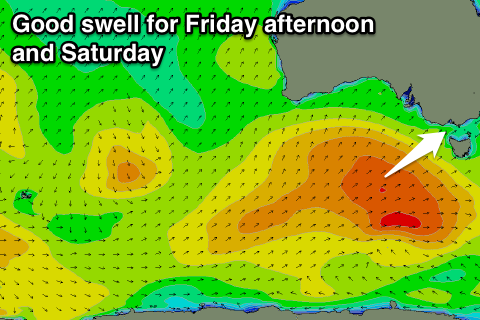
Good week ahead, largest from Friday afternoon
Victoria Forecast by Craig Brokensha (issued Monday 20th February)
Best Days: Tuesday both coasts (west of Melbourne more from late morning), Wednesday morning both coasts, Thursday onwards Surf Coast
Recap
Plenty of swell Saturday morning but bumpy although workable conditions across the Surf Coast with a moderate onshore wind and average waves to the east. W'ly winds overnight unfortunately swung to the south just before dawn.
Sunday started average with easing levels of swell and E/SE breeze, but conditions improved through the morning east of Melbourne as winds swung more E/NE and then more variable ahead of afternoon sea breezes.
This morning conditions were clean and fun across both coasts with a leftover 2ft of swell to the west and better 3-4ft sets to the east.
This week (Feb 23 - 2)
Tomorrow morning should be another cracker across the beaches east of Melbourne, while the beaches will also be the best to the west. Morning offshore NE winds are due to swing more N'ly late morning ahead of a shallow SW change into the afternoon.
Before this change we may actually see winds swing NW on the Surf Coast, so keep an eye on local obs. A new SW groundswell should provide fun 2-3ft waves across most locations with 5ft sets on the Mornington Peninsula.
Wednesday's secondary better pulse of groundswell looks to now be of similar size to Tuesday's and conditions will be good again early with local offshore breezes ahead of afternoon sea breezes.
Easing surf is due through Thursday with W/NW tending W/SW winds, favouring the Surf Coast, but get in through the morning for the most size and best conditions.
 Now, our stronger episode of SW groundswell for the end of the week and weekend is still on track, but the whole progression generating the swell isn't as strong as forecast on Friday.
In saying this winds are looking more favourable though, mainly for the Surf Coast.
Through tomorrow a strong polar front is forecast to be projected ideally up through our south-western swell window while weakening. A slight re-intensification just to our south-west during Thursday should help kick the size a little, with a moderate sized SW groundswell due to develop.
The swell should build through Friday and reach 3-5ft on the Surf Coast into the afternoon and 6-8ft on the Mornington Peninsula. A secondary reinforcing pulse for Saturday morning is due from a weaker frontal system pushing in over the back of the main progression, coming in at 3-4ft+ on the Surf Coast and 6ft+ on the Mornington Peninsula before easing back through Sunday.
W/NW winds are due each morning on the Surf Coast, creating clean conditions with protected spots the pick to the east of Melbourne.
Longer term a good pulse of long-period SW groundswell is due Monday from a tight and intense polar low, but more on this Wednesday.


Comments
How shallow is shallow you think craigo?
Looking at Cape Otway, very shallow. But 10-15kt gusts or so, backing off into the evening.
http://www.bom.gov.au/products/IDV60801/IDV60801.94842.shtml
I generally check cape otway for rough little glimpse into the morn pen wind future but it always seems that when it gets here its stronger. Maybe the mountain ranges at the C.O tame it a bit?