Workable weekend both coasts, clean early next week ahead of larger swell late
Victoria Forecast by Craig Brokensha (issued Friday 19th February)
Best Days: Surf Coast Saturday morning, east of Melbourne from mid-morning Sunday, both coasts Monday and Tuesday, Surf Coast Wednesday morning
Recap
Workable waves across the Surf Coast yesterday morning with an easing swell and early light W/SW breeze before giving into a stronger onshore. Locations to the east were poor.
This morning a new SW groundswell has started to fill in with clean conditions on the Surf Coast early and waves varying from 2ft to 3-4ft depending on exposure. The Mornington Peninsula was average again with fresher W/NW winds and limited options.
This weekend (Feb 20 - 21)
Today's building SW groundswell will be replaced by a new SW groundswell from a strengthening frontal system that's currently just to our immediate south-west (linked to today's onshore change).
This should keep good 3ft sets hitting the Surf Coast tomorrow with possible larger sets at swell magnets, and sets in the 6ft range on the Mornington Peninsula.
Winds are now looking better for the Surf Coast with a morning W/NW'ly more than likely, while remaining spots will see moderate S/SW breezes.
A weaker reinforcing SW swell from a secondary weak trailing front should slow the easing trend through Sunday with easing 2-3ft waves on the Surf Coast and 5ft waves on the Mornington Peninsula. Conditions will be best to the east and improving through the morning with an early E/SE tending E/NE breeze ahead of afternoon sea breezes.
Next week onwards (Feb 22 onwards)
Local offshore winds and a fun small swell is expected on Monday with 2ft sets on the Surf Coast and 3-4ft waves on the Mornington Peninsula.
Later in the day but more so Tuesday a new SW groundswell is due from a healthy pre-frontal fetch of W/NW winds moving in from the Indian Ocean, followed by a better pulse Wednesday from a better aligned system.
The Surf Coast should offer inconsistent 2-3ft waves Tuesday with 5ft sets on the Mornington Peninsula with favourable morning offshores again.
Wednesday's swell will be slightly bigger but with the Surf Coast offering the best conditions with fresh W/NW offshores ahead of a strong SW change.
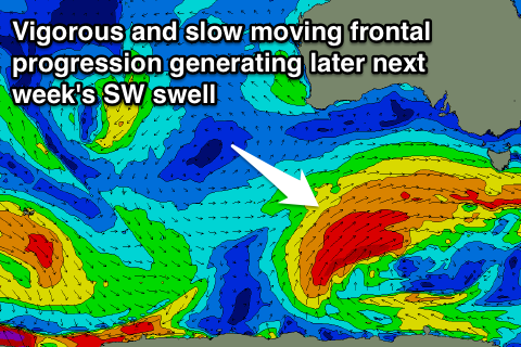
 This change will be linked to a relatively weak front moving through ahead of a much more significant polar frontal progression through our swell window, touched on earlier this week.
A strong node (peak) of the Long Wave Trough will move in from the west during next week, directing a vigorous polar frontal progression from well south of WA, slowly up towards us through the middle to end of next week.
A couple of moderate to large SW groundswell pulses are due off this progression, the first building through Friday ahead of a better secondary pulse Saturday.
Size wise we're looking at a peak in the 4-6ft range on the Surf Coast and 8ft+ on the Mornington Peninsula Saturday morning with SW winds. Check back here Monday for a much clearer idea on this though. Have a great weekend!


Comments
Thank you Craig. Friday's early clean conditions were only a reprieve from dark clouds to the SW, then you could definitely see the change as a line of cloud moving in with the SW wind change. Sometimes it's nice to be out there in the weather changes. Forecast looks like fun, very Autumny.
What sort of water temps are down the surf coast way at the moment as in wetty requirements. I'm going to be down there next week. Would a short arm steamer be needed for mornings at the moment.
cheers
cd. I reckon the water is pretty toasty (for Vicco) at the moment. All comes down to personal preference. At Bells yesterday one bloke was surfing in boardies and a rashie, the bloke next to him steamer and booties!!! Short sleeve 2/2 steamer is my go to at the moment.
Thanks for the feedback jezza, i'll pack the s/s steamer.
Yeah nice and balmy up around 20 degrees.