Plenty of swell, limited windows of clean conditions
Victoria Forecast by Craig Brokensha (issued Wednesday 17th February)
Best Days: Keen surfers Surf Coast tomorrow morning, early Surf Coast Friday, keen surfers both coasts Saturday morning, east of Melbourne Sunday and Monday
Recap
Large stormy waves yesterday with a strong SW groundswell but poor onshore SW winds.
Today the swell has eased back with more favourable conditions in protected spots on the Surf Coast with a morning NW breeze. In saying this winds only shifted offshore around dawn resulting in the swell being a little bumpy and uneven. Winds are due to swing back onshore soon so make the most of the current conditions.
This week and weekend (Feb 18 - 21)
Tomorrow is looking for the most part average but workable on the Surf Coast. A reinforcing SW groundswell should keep 3ft sets hitting exposed spots west of Melbourne most of the day with 5ft+ waves on the Mornington Peninsula, easing later. Moderate S/SW winds are due, with only a very slim chance for an early W'ly around Torquay.
Friday should offer a better window of early W/NW winds ahead of a strong S/SW change around 8am or so. A new SW groundswell is also due to be in the water, generated by good pre-frontal fetch of NW gales the last couple of days south-west of WA.
A kick back to 3ft+ on the Surf Coast and 6ft on the Mornington Peninsula is due, but remember get in early to the west of Melbourne.
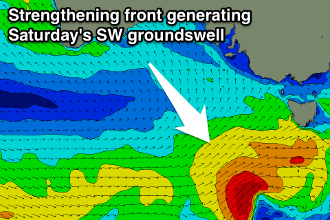
 Friday's swell is due to ease back into Saturday only to be replaced by a new short-range SW swell from a small strengthening polar front pushing towards Tassie over the coming days.
A fetch of strong SW winds will be initially generated, reaching the gale-force range just before passing under Tassie Friday.
Another good kick to 3ft is expected on the Surf Coast, with 4-6ft waves on the Mornington Peninsula but winds are due to linger from the S/SE. There won't be too much strength to the breeze creating workable conditions for keen surfers.
Sunday is the day to surf though with easing 2-3ft sets on the Surf Coast and 5ft waves on the Mornington Peninsula with E/NE tending N/NE winds ahead of afternoon sea breezes.
Next week onwards (Feb 22 onwards)
The surf's due to bottom out Monday morning, with the Mornington Peninsula the pick under NE winds and with 3-4ft of swell.
Fun pulses of SW groundswell are due through most of the week with varying winds, but of greater significance is a stronger polar frontal progression that's due to form during the middle of the week. This could produce a moderate to large SW groundswell for later in the week, but check back here Friday for more on this.


Comments
Early W/MNW winds? M? W is the devils wind. M is W upside down. That makes M winds heavenly. M is the new NE.
Ha, changed.