Generally average weekend, improving from mid-next week
Victoria Forecast by Craig Brokensha (issued Friday 25th December)
Best Days: Early Saturday and Sunday keen surfers Surf Coast, Tuesday morning both coasts, Wednesday morning both coasts (beaches to the west), Thursday both coasts
Recap
A slow start to yesterday morning with average 1-1.5ft sets on the Surf Coast and cleaner 2-3ft waves on the Mornington Peninsula.
Today an inconsistent long-range W/SW groundswell has come in at a good clean 3ft+ on the Surf Coast with 6ft sets on the Mornington Peninsula, under fresh and gusty N'ly winds favouring the beaches west of Melbourne over the reefs. The swell will ease a touch into this afternoon as offshores persist.
This weekend and next week (Dec 26 – Jan 1)
Make the most of today, as a cool strong onshore change due early tomorrow morning is due to create poor conditions across most spots with a smaller 2-3ft wave on the Surf Coast and 5-6ft sets on the Mornington Peninsula.
The odds of winds swinging W'ly for a period around Torquay have increased tomorrow morning, so keep an eye on the local observations.
Into Sunday a mix of new W/SW groundswell from a front currently pushing through the Bight, and then SW swell from a polar low forming to our south-west is looking to come in more around the 3ft range on the Surf Coast and 6ft on the Mornington Peninsula.
Conditions will remain average across most locations with a moderate S/SW'ly, although Torquay is again likely to see an early short-lived W'ly.
Into early next week the mix of swells should ease from 2-3ft on the Surf Coast and 5-6ft on the Mornington Peninsula along with lingering SE-E/SE winds. While not great, conditions should be workable across most spots for keen surfers.

A more variable breeze Tuesday morning should provide cleaner conditions with a small reinforcing W/SW swell to 2ft+ on the Surf Coast and 3-5ft east of Melbourne.
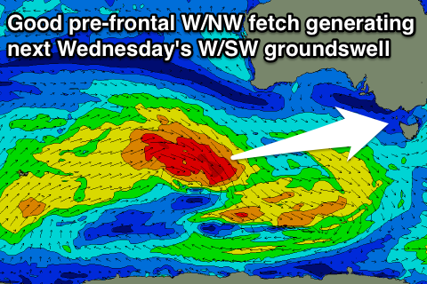
Wednesday should see a fun pulse of W/SW groundswell generated by a strong pre-frontal fetch of W/NW gales moving through our western swell window in the south-east Indian Ocean through the weekend.
The Surf Coast is expected to offer good 3ft sets, with the odd bigger bomb likely at exposed spots like 13th Beach, while the Mornington Peninsula should offer 5-6ft+ sets. Good conditions are due across the beaches with a morning N/NE offshore ahead of afternoon sea breezes.
Cleaner conditions are due on the Surf Coast Thursday as the swell slowly eases. This easing trend will be softened though by a weaker but broad trailing fetch of W/SW winds behind the main front, but we'll review this Monday. Have a great Christmas Day!


Comments
Nice craig how does this one compare to the last swell on xmas closer range yeah
Closer range yes and of similar size, so more consistent, but not as powerful.
Ok good news Craig Will be alerted then , has the storm lived up ?
Yeah read here: https://www.swellnet.com/reports/forecaster-notes/victoria/2015/12/28/fun-week-ahead-best-wednesday-and-thursday