Christmas Day set to deliver
Victoria Forecast by Craig Brokensha (issued Monday 21st December)
Best Days: East of Melbourne Wednesday and Thursday mornings for small waves, Friday!
Recap
Small clean 1-2ft waves on the Surf Coast Saturday morning, but better to the east with 3-4ft sets. Sunday morning was again best east of Melbourne with clean 3ft waves before an onshore change moved through mid-late morning.
Today the surf is poor across both coasts with a weak increase in mid-period SW swell and onshore winds.
This week and weekend (Dec 22 - 27)
The week ahead isn't looking too flash until Friday (Christmas Day) and it's looking to be a scorcher!
Today's increase in mid-period swell will ease back through tomorrow and early conditions will be average with a moderate SE'ly. This might ease through the mid-morning before freshening into the afternoon again. The Surf Coast is only due to ease from a small 2ft with 3-5ft sets on the Mornington Peninsula.
Cleaner conditions are due Wednesday morning with a light offshore across the Mornington Peninsula (likely variable on the Surf Coast) but the swell will be minimal, with swell magnets east of Melbourne the pick with 2-3ft sets early.
Thursday should be clean again east of Melbourne with a N/NE offshore but there'll be hardly any swell with inconsistent 2ft+ sets across the Mornington Peninsula.
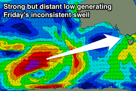
Of greater significance is an inconsistent W/SW groundswell mentioned about last week. This swell will be generated by a vigorous and slow moving polar low that's fired up south-west of WA under the influence of the Long Wave Trough.
 A fetch of severe-gale to storm-force W/SW winds in our far swell window has already been generated and picked up by satellite, with the low due to weaken slightly and stall in its position through tomorrow and Wednesday before sling-shotting east through our western swell window during the end of the week.
What we can expect is an inconsistent but strong long-range W/SW groundswell to arrive late Thursday, peak through Friday to 3-4ft at swell magnets on the Surf Coast and 6ft to occasionally 8ft on the Mornington Peninsula. Expect very long waits between sets though.
Due to the prolonged nature of the low, the swell will only slowly ease into Saturday and still offer 3ft sets on the Surf Coast through the morning, 6ft on the Mornington Peninsula before fading a touch further through the afternoon.
One final pulse of W/SW swell is due Sunday from the projection of the low through our western swell window, with the Surf Coast likely to kick back to 3ft or so on the sets and 6ft to the east.
Now, conditions will be best Friday with a fresh hot offshore wind due across both coasts, persisting all day creating excellent conditions!
Into Saturday an strong SW change is due, creating poor conditions but bringing rain and cooler weather, and onshore S/SE winds are due to persist into Sunday. Therefore make the most of Friday!


Comments
Couple of small peelers at Lorne - surprising given the lack of swell across the region.
Sup brigade on it
South angle swell
You been sussing out lorne point caml?
Haha, totally!
Haha!
No I haven't , but I do see whats going on in the ocean & use the swell buoys from tassie to wa & they showed a sth swell .albany had it se actually
Going to be a merry Christmas on the isle of the gods too.
Ho ho ho.
Yes, boss, yes ! Shopping ?! Transport !? Uluwatu !?
Unrelated - Craig on the lead headlines for Sydney Morning Herald.
I knew him before he was famous.
Haha, what a year, from dolphins to Kelly's Wave Pool!
Woah !
Now it turns out you've been on TV as well !
Like a better looking Owen Wilson no less !*
*Note- I haven't actually seen the footage and am just saying what I imagine you'd like to hear as a little Chrissy pressy for all your good work throughout the year. Enjoy !
.
Ben the buoys show some squiggles in the period graphs tas cdc & I can see it on swellnets breakdown of 2nd & 3rd swells is that a prime example of whats happening now ?
Yep that's very similar Camel. Mix of swells, with the long period being very faint. So therefore no major size.
Not yet but wont be long , j curves to the west !
Yep, expect a solid kick this afternoon Cam!
Hohoho ! Cheers
Seeing the swell at the coast Cam? CDC starting to kick now!
Yeah craig . it went from too small to too big within an hour ! If we were unaware of why u would be spooked like in the last century , no good waves tho here , will search further this arvo
Great swell but too bigger period for my reef Bummer ,could have ventured to score but didnt . Cdc showed less than3m but that pure period was the factor hows how the period graph showed bottom line so much higher than usual . (Tz average wave period )
The Average Period was so high, because bascially there was only that one strong SW groundswell in the water.
If there's another swell, or windswell contaminating it as seen today with the change, it drops right out.
So yeah, when peak and average period are close, that signifies one swell in the water.
Just follow the arrows. ..i now that