Great week ahead
Victoria Forecast by Craig Brokensha (issued Monday 23rd November)
Best Days: Every day on the Surf Coast, east of Melbourne Wednesday
Recap
A small kick in W'ly swell Saturday to a bumpy 2ft on the Surf Coast and 4-5ft on the Mornington Peninsula with deteriorating conditions through the day.
Yesterday morning was around the same size with small clean waves on the Surf Coast and average surf to the east, but a strong and powerful SW groundswell filled in through the afternoon kicking to an easy 4-5ft with 5-6ft sets at Bells and Winki with workable W/SW winds.
Today the swell was hanging in with clean 4-5ft waves across the Surf Coast again, while the Mornington Peninsula was a bumpy 6ft+.
This week (Nov 23 - 27)
 Yesterday afternoon's and this morning's strong pulse of SW groundswell is the first of a series of strong swells due through the coming period.
Firstly a reinforcing SW swell is due this afternoon generated on the tail of the polar frontal progression responsible for the current swell and this should keep 3-5ft sets hitting the Surf Coast with 6-8ft sets on the Mornington Peninsula, but with W/SW winds.
This swell should ease back through tomorrow morning from a similar size, but later in the day another pulse of SW groundswell is due, peaking Wednesday morning.
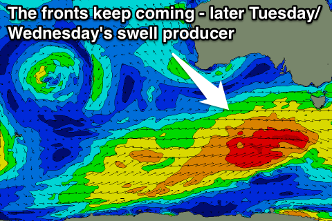
The source of this swell is a vigorous polar front that's developed south of WA, and will be steered up towards us under the second strengthening node of the Long Wave Trough currently developing to our west.
Another pulse to 3-5ft and 6-8ft respectively is due later Tuesday and Wednesday morning, easing into the afternoon.
Following this a weaker and slightly less favourably aligned front will push up into South Australia, generating one final pulse of significant W/SW groundswell for Friday morning.
While the track and strength isn't ideal, it will still push nicely through our swell window in any case generating another 3-5ft of swell for the Surf Coast with 6-8ft sets to the east.
Now, conditions will be best on the Surf Coast all week (good to the east Wednesday), with NW offshores tomorrow (lighter into the afternoon and more W'ly), N'ly tending fresh N/NW winds Wednesday, and W'ly tending W/SW breezes Thursday. Friday will continue the trend with morning W/NW winds, swinging W/SW through the afternoon as the swell starts to ease.
This weekend onwards (Nov 28 onwards)
Into the weekend we'll be on a slow downwards trend in size as the close-range frontal activity subsides, with offshore NW winds for the Surf Coast Saturday morning and Sunday morning. There's a chance for a N/NW'ly to the east, but we'll review this on Wednesday and Friday.
Longer term some new swell energy is due into early-mid next week, but we'll have another look at this on Wednesday.


Comments
I think your best days are a bit confusing there criago. Unless my dyslexia has gotten the better of me again im seeing W's where theres meant to be E's ;)
Crap, sorry forgot to edit that again. Cheers.