Uninspiring week, good swell due early next week
Victoria Forecast by Craig Brokensha (issued Monday 16th November)
Best Days: Early Tuesday east of Melbourne, desperate surfers Surf Coast Wednesday morning, next Monday Surf Coast
Recap
Good clean fun 3-4ft waves across the Surf Coast Saturday morning with a new but inconsistent W/SW swell and W/NW winds. Conditions started to deteriorate from mid-morning, with poor and messy onshore 6ft+ surf on the Mornington Peninsula.
Sunday was average across both coasts with a smaller easing swell and lingering onshore S/SW winds.
Today the swell was small and easing from 2ft on the sets across Surf Coast and 3-4ft on the Mornington Peninsula with light N/NE winds east of Melbourne and at 13th Beach, but light onshore around Torquay.
This week and weekend (Nov 17 - 22)
Early tomorrow morning will see the surf ease further across the state, with tiny 1ft+ waves left across the Surf Coast and 3ft+ sets on the Mornington Peninsula, ahead of a slight kick in size through the day.
Winds will be best early with a N'ly on the Mornington Peninsula, providing the best conditions before swinging NW late morning and then onshore into the afternoon. The Surf Coast will be clean until probably mid-afternoon, with the late morning at exposed breaks probably the best to possibly catch a 1-2ft wave (3-4ft on the Mornington Peninsula).
Our small pulse of W/SW swell from a mid-latitude low Wednesday has unfortunately been downgraded, with the low not expected to really develop with any strength today or tomorrow.
Morning W/NW winds are still due across most spots, but with a small fading 1ft to maybe 2ft wave on the Surf Coast and 3ft+ sets on the Mornington Peninsula.
Thursday will then be a lay day with tiny surf and fresh N/NW tending W/SW winds.
Into the end of the week, a very acute W'ly swell may be seen on the Mornington Peninsula later Friday, but it won't have any affect on the Surf Coast. This is because the mid-latitude low forming off the south-west of WA, generating the swell will be too far north and not produce a favourably aligned fetch at all.
 The swell is due to arrive later in the day, and this will be with onshore S/SE winds in any case, after morning NE breezes.
The swell is due to peak Saturday morning but only in the inconsistent 3-4ft range if that on the Mornington Peninsula, just as a W/SW tending SW change moves through, leaving no decent surfing options.
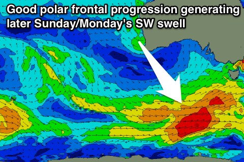
This onshore change will be linked to the final stages of a strong polar frontal progression forming south-west of WA on the Wednesday and swinging up towards us through the end of the week and Saturday, producing a good SW groundswell arriving later Sunday and peaking early Monday.
Size wise we're currently looking at peak in the 3-5ft range on the Surf Coast and 6-8ft on the Mornington Peninsula, with W/NW winds Monday morning, but we'll review this again on Wednesday.

