Fun protected reefs Saturday morning, more windows next week
Victoria Forecast by Craig Brokensha (issued Friday 13th November)
Best Days: Saturday morning Surf Coast, both coasts Monday morning, east of Melbourne early Tuesday, Surf Coast Wednesday morning
Recap
Lumpy, peaky but improving waves across both coasts yesterday morning with variable breezes and easing 2-3ft waves on the Surf Coast with 4-5ft sets on the Mornington Peninsula. An onshore change moved through around midday, and this has persisted into today with similar amounts of swell.
This weekend (Nov 14 - 15)
Our small window of possibly W'ly winds around Torquay tomorrow morning looks to be on track with a reprieve in the SW air stream likely to see W/NW winds develop around the region for a period.
This will be along with a good new W/SW groundswell generated earlier this week. The Surf Coast should see inconsistent but good 3-4ft sets, with the odd bigger bomb likely at swell magnets like 13th Beach, while the Mornington Peninsula will be a messy 6-8ft.
Make the most of the morning around Torquay, as winds will swing back onshore late morning and then persist Sunday from the S/SW to S/SE. There's still a slim chance of winds tending variable across both coasts through the morning as a small surface trough lingers in the region, but keep an eye on local observations for this. Saturday's swell should ease gradually through the day, but with plenty of size still on offer early.
Next week onwards (Nov 16 onwards)
Monday will finally see winds swing offshore for the Mornington Peninsula with a N/NE morning offshore (tending light N/NW on the Surf Coast) with small easing 2ft sets west of Melbourne and 3-5ft surf to the east. Afternoon sea breezes are more than likely, although we may see more variable winds at selected locations.
 Tiny surf is due into Tuesday morning, ahead of a slight kick in SW swell through the late morning/afternoon but only to 1-2ft on the Surf Coast and 3-4ft on the Mornington Peninsula. NW winds are expected on the Surf Coast ahead of a gusty afternoon W/SW change. The Mornington Peninsula should see favourable N'ly winds at dawn with fun 3ft sets for keen surfers.
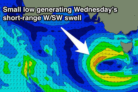
Tuesday's change will be linked to a small, weak but slow moving mid-latitude low pushing through our swell window Tuesday and Wednesday, with a small spike in short-range W/SW swell due Wednesday, peaking into the afternoon.
The Surf Coast may see 2-3ft sets developing during the day, with larger 4-5ft waves on the Mornington Peninsula with W/NW to SW winds.
The swell will drop quickly Thursday with possible early N'ly winds ahead of another SW change, so hit up swell magnets early.
Longer term there's nothing too major on the cards, so make the most of the windows of fun waves coming through the period ahead. Have a great weekend!


Comments
Hey is tomorrow morning still looking offshore (NE) for SW vicco ? Hope youre having a good weekend,
Cheers
In these sombre times, it's best that everyone speaks out in a considered and thoughtful way. This guy is truly an #inspiration to us all, and has a Gaz-worth rig too.
https://instagram.com/p/-FO4W7ptZZ/
Hey Craig, just wanna say great call re saturday morning. Keep up the good work buddy.
Cheers Gannet, glad you got some good ones!