Make the most of the coming days
Victoria Forecast by Craig Brokensha (issued Wednesday 19th August)
Best Days: Thursday east of Melbourne and beaches Surf Coast, Friday both coasts, Sunday morning east of Melbourne
Recap
Lumpy and far from perfect but solid swell easing from the 4-5ft range across the Surf Coast yesterday, with larger 6-8ft sets on the Mornington Peninsula. This morning was much better with local offshore winds and clean 3ft waves on the Surf Coast and 4-5ft sets on the Mornington Peninsula. Winds will swing more E'ly through the afternoon as the swell remains steady, favouring spots east of Melbourne.
This week and weekend (Aug 20 - 23)
Tomorrow's strong S/SW groundswell is still looking good, with satellite observations picking up the fetch generating the swell nicely with 30-45kts of wind aimed through our southern swell window.
This swell should build through tomorrow and reach a strong 3-4ft across the Surf Coast into the afternoon with 5-6ft+ waves on the Mornington Peninsula. Fresh to strong N/NE winds will favour locations east of Melbourne, and the beaches on the Surf Coast.
Friday morning will be great across the beaches across both coasts as the swell eases under fresh to strong N'ly tending N/NW winds.
The weekend isn't looking too flash with the swell bottoming out on the Surf Coast with leftover 1ft to maybe 2ft waves at swell magnets, and 3ft+ sets on the Mornington Peninsula but with a NW tending W/NW breeze.
Sunday will be a similar size and winds will be funky as a surface trough moves across the region bringing a weak S'ly change. Winds may be variable most of the morning though, with the Mornington Peninsula the best option. A late increase in long-range and inconsistent SW groundswell may be seen but with onshore winds.
 Next week onwards (Aug 24 onwards)
Unfortunately next week is looking poor, even with some decent long-range SW groundswell energy due to fill in.
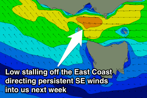
The trough moving across us Sunday will stall off the East Coast and strengthen, aiming an increasing fetch of SE winds through Bass Strait from Monday, creating poor conditions and kicking up moderate levels of SE windswell.
This looks to dominate our swell window all off next week, with some relief the following weekend. So with this in mind, make the most of the coming days of waves!


Comments
Hi Craig,
Are the variable winds on Sunday morning likely to include the region in the vicinity of the Otways or is that surface trough going to get there earlier and spoil the party ?
Touch and go at the moment, looks onshore to the west of the Cape and just immediately east, then variable further towards Lorne.
Thanks! Appreciate that this is a sensitive region so thanks for replying.
Nice lines across the MP this morning.
Nice afternoon on the beaches..