Tricky period, best across the Surf Coast
Victoria Forecast by Craig Brokensha (issued Friday 10th July)
Best Days: Saturday afternoon Surf Coast, early Sunday Surf Coast, Tuesday Surf Coast, Wednesday both coasts
Recap
Tiny waves on the Surf Coast yesterday morning with 2-3ft sets on the Mornington Peninsula, before a fresh mix of W/SW swells filled in and reached 4-5ft on the Mornington Peninsula, with infrequent 2ft sets on the Surf Coast. Winds remained favourable for exposed breaks across the state, while today, the swell has dropped back to a tiny 1-1.5ft with the odd 2ft bomb at swell magnets on the Surf Coast and 3-4ft on the Mornington Peninsula under an early lighter N'ly wind which has since strengthened.
 This weekend and next week (Jul 11 – 17)
Tomorrow is looking better on the Surf Coast, as a new W/SW groundswell fills in with exposed spots due to build to 3ft during the day, with 5-6ft sets on the Mornington Peninsula.
Winds will be best on the Surf Coast with a fresh N/NW tending NW and W/NW breeze, but the Mornington Peninsula should see a straighter N'ly through the morning.
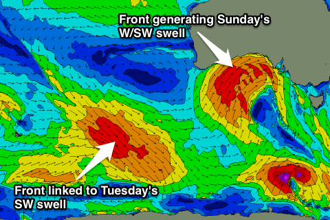
Come Sunday our new pulse of slightly better W/SW groundswell is due, from a strong cold front currently pushing up and into SA.
This swell should offer a touch more size with 3ft to occasionally 4ft sets across the Surf Coast and 6ft+ waves on the Mornington Peninsula.
Winds are looking favourable for the Surf Coast through the morning, as the front responsible for the swell stalls and weakens to our west, with an offshore W/NW breeze due to give way to a fresh SW change through the day. If the low stalls a little longer than currently forecast, we could actually see variable winds early Sunday, favouring the Mornington Peninsula as well.
Into Monday, Sunday's swell is due to ease, with some smaller S/SW swell in the mix, from the backside of the weakening low over the weekend. The Surf Coast is due to drop from 3ft+, and the 6ft range on the Mornington Peninsula.
Winds are due to still be onshore and strong from the SW though, with only an outside chance of a brief early W'ly around Torquay.
Tuesday will be the day to surf, as winds swing offshore from the W/NW tending NW, and a new moderate sized SW groundswell fills in.
This will be generated by a broad pre-frontal fetch of W/NW gales swinging in from the Indian Ocean, to be followed by a stronger fetch of W'ly gales along the polar shelf tomorrow and Sunday.
An inconsistent SW groundswell should result, peaking Tuesday morning to an inconsistent 3ft+ on the Surf Coast and 6ft+ on the Mornington Peninsula.
A drop in size is then due into Wednesday morning, ahead of a long-period W/SW groundswell through the afternoon. This should be generated by a cut-off low developing south-west of WA and projecting a fetch of severe-gale to storm-force W/SW winds through our western swell window, before pushing up into SA again.
The size of this swell looks to be a touch bigger than Sunday's swell with the Surf Coast due to build to an infrequent 3-4ft+ with 6-8ft sets on the Mornington Peninsula under N'ly breezes.
We'll have to review this again on Monday though, as one of the other models has the low pushing closer towards us, with more size possible but with less favourable winds. Have a great weekend!


Comments
Thank fuck it's gone onshore and the weekend cycle has been broken, I couldn't take it anymore, it's cold and my arms are worn out.:-)
Saturday's swell came in as forecast as you can see below, but Sunday's (the trickier of the two) didn't really show at all. The window for clean conditions was small in any case.
Pics, Shan Aust