Exposed spots the pick ahead of better swells next week
Victoria Forecast by Craig Brokensha (issued Wednesday 29th April)
Best Days: Exposed spots Thursday, Friday and Saturday morning, Sunday on the Surf Coast, Monday exposed spots. Tuesday afternoon on the Surf Coast, Wednesday Surf Coast
Recap
Average onshore 3ft+ surf west of Melbourne with messy 4-6ft waves to the east yesterday. Today a lighter and more variable breeze has resulted in cleaner conditions across both coasts with a bumpy 2-3ft of swell on the Surf Coast and bumpy 3-4ft waves on the Mornington Peninsula. This is the cleanest the surfs been in a while and worth making the most.
 This week and weekend (Apr 30 – May 3)
Exposed breaks will be the pick over the coming days as the swell remains small and winds swing northerly.
A further drop in swell is due through tomorrow across both coasts with inconsistent 2ft+ sets on the Surf Coast and 3-4ft+ waves on the Mornington Peninsula under favourable N/NE winds ahead of weak SE sea breezes.
Friday will start slow with leftover 1-2ft sets on the Surf Coast and 3ft to occasionally 4ft waves on the Mornington Peninsula ahead of an inconsistent new SW groundswell through the day. The source of this swell is a very strong but unfavourably tracking polar low, generating a fetch of severe-gale to storm-force W/NW winds to our south-west.
This swell should boost the Surf Coast back to 2ft to possibly 3ft through the day and 4-5ft on the Mornington Peninsula under persistent N/NE tending NE winds. A full fun day of waves is expected across the beaches on both coasts.
Into Saturday, Friday's kick in SW swell will rapidly ease, dropping from 2ft on the sets at exposed breaks with the Mornington Peninsula easing from 3-4ft.
Winds will be favourable for the Mornington Peninsula early with a fresh to strong and straight N'ly wind before shifting NW through the late morning and W/NW later in the day.
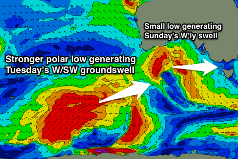
This westerly change will be related to a weakening mid-latitude low pushing in from the west and with this we should see a slight kick in W/SW swell through the day but only to 2ft+ on the Surf Coast and 3-5ft on the Mornington Peninsula. This will be due to the low sitting too far north and mainly out of our swell window as it pushes east through the Bight.
Conditions will be best on the Surf Coast with a NW tending variable breeze.
Next week onwards (May 4 onwards)
Sunday's W/SW swell should ease into Monday from a small 2ft on the Surf Coast and 3-4ft on the Mornington Peninsula under local morning offshore winds (N/NE east of Melbourne and N/NW to the west). Winds may tend a little more N/NW through the day on the Mornington Peninsula, favouring the western end breaks.
Of much greater importance and discussed in the last couple of updates is the development of a moderate sized W/SW groundswell next week as a strong node (peak) of the Long Wave Trough moves in from the west.
This will steer and strengthen a vigorous polar low up from the Heard Island region towards Western Australia, producing two inconsistent but good W/SW groundswell pulses for Tuesday and Wednesday, while a secondary vigorous polar system forming to our south-west early next week should generate a better SW groundswell for Thursday.
Size wise we should see the Surf Coast build to a good 3-5ft through Tuesday with 6-8ft sets on the Mornington Peninsula, easing a touch back to 3-4ft and 6ft+ respectively into Wednesday as the secondary W/SW pulses fills in, generated by a secondary intensification on the backside of the initial polar low.
Winds on Tuesday are looking dicey but should improve with a vigorous front pushing through overnight leaving fresh to strong W/SW winds in its wake. Another approaching front will swing winds back to the W/NW into the afternoon though, creating good waves into the evening on the Surf Coast.
Wednesday then looks fun all day on the Surf Coast with a NW tending W/NW breeze.
Thursday's possible follow up SW groundswell looks to be more in the 4-6ft range across the Surf Coast, but we'll have another look at this on Friday.

