Fun waves up until Thursday, improving over weekend
Victoria Forecast by Craig Brokensha (issued Monday 30th March)
Best Days: Tuesday morning both coasts, Wednesday both coasts, Saturday morning beaches both coasts, Sunday morning both coasts
Recap
Great waves across the Surf Coast Saturday morning with a clean easing 3-4ft of swell under offshore winds which persisted into the afternoon.
Sunday was smaller but cleaner across the Mornington Peninsula with 4-5ft sets, while the Surf Coast was still in the fun 2-3ft range.
Today a new SW groundswell has filled in with 3ft surf west of Melbourne with the odd bigger one in the mix, and bumpy/lumpy 5-6ft waves on the Mornington Peninsula. The swell should ease a touch through the day as winds tend onshore early-mid afternoon.
 This week (Mar 30 – Apr 3)
This morning's SW groundswell is the first of two due across the state over the coming days, with the second swell due tomorrow morning but with a slight downgraded in size from Friday.
This is due to the second frontal system pushing in from the west over the weekend and last night coming in weaker than forecast on Friday with the bulk of the fetch being W/NW in nature and aimed towards the Polar Shelf.
We're now looking at the Surf Coast coming in at 3-4ft, with 6ft+ sets across the Mornington Peninsula, persisting most of the day before dropping away through Wednesday from 3ft and 5-6ft respectively.
Conditions look good for both coasts tomorrow though with light variable winds that should tend locally offshore across each region before afternoon sea breezes kick in.
Come Wednesday as the swell starts to ease winds will be great for the beaches across both coasts through the morning, improving for the Surf Coast reefs through the day with a moderate to fresh N'ly tending lighter NW wind.
Thursday is looking poor as a gusty onshore change moves through the early morning associated with a eastward moving trough, and the swell will be smaller, easing from 2ft+ on the Surf Coast and 3-5ft on the Mornington Peninsula.
This change is expected to kick up a weak windswell through the day but to no quality, while Friday is expected to see an easing SE windswell across the Surf Coast ahead of a late increase in new SW groundswell.
Conditions look to be average though with a lighter E/NE breeze through the morning and peaky weak 2ft of SE windswell, while the Mornington Peninsula is also only due to be around 3ft or so.
This weekend onwards (Apr 4 onwards)
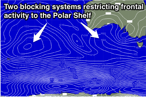
There's nothing too major on the cards at all from the weekend into next week with a blocking pattern setting up across southern Australia, restricting all the frontal activity to polar latitudes. This will lead to only small to moderate amounts of inconsistent SW groundswell along with average winds.
The first pulse of SW groundswell is due Saturday morning to an inconsistent 3ft on the Surf Coast and 5-6ft on the Mornington Peninsula, as winds tend more NE. The swell should drop slowly through Sunday and we may see better N'ly winds across both regions, creating fun conditions across the beaches.
Come Monday a slightly smaller SW groundswell (compared to Saturday) is on the cards with better W/NW winds for the Surf Coast, but we'll have a closer look at this on Wednesday.

