Good options both coasts over coming period
Victoria Surf Forecast by Craig Brokensha (issued Friday 27th March)
Best Days: Saturday morning Surf Coast, Sunday morning both coasts, Monday morning Surf Coast, Tuesday and Wednesday mornings both coasts
Recap
 Yesterday morning played out as expected with a new inconsistent SW groundswell slowly filling in across both coasts, coming in at an inconsistent 2-3ft on the Surf Coast and 5ft or so on the Mornington Peninsula under fresh to strong NW winds.
The low that was stalling to our west actually fell just within our swell window, with satellite observations showing a fetch of 35-35kt winds aimed just south of Cape Otway yesterday morning (pictured right).
This produced a strong pulse of W/SW swell which pulsed through the late morning and into the afternoon across both coasts, reaching 4-6ft on the Surf Coast and 6-8ft on the Mornington Peninsula. Winds strengthened from the W/NW before rain set in resulting in winds easing back from the NW. This made for a great day of surf west of Melbourne, while today is average as expected with a raw mix of swells and poor winds which were lighter and more W'ly around Torquay early.
This weekend (Mar 28 - 29)
Today's mix of SW windswell and easing SW groundswell should drop this arvo and further into tomorrow, but a new SW groundswell is due to steady wave heights through the day before the easing trend continues through Sunday.
The Surf Coast should hold around 3ft all day tomorrow, easing from 2-3ft Sunday with 6ft sets on the Mornington Peninsula tomorrow, dropping from 4-5ft+ Sunday.
Conditions will be best on the Surf Coast tomorrow with a W/NW breeze through the morning and onshore W/SW winds everywhere else. Sunday should be clean across both regions early with N/NW winds on the Surf Coast and a N'ly on the Mornington Peninsula before swinging W/NW through the late morning and onshore from the W/SW late afternoon.
 Next week onwards (Mar 29 onwards)
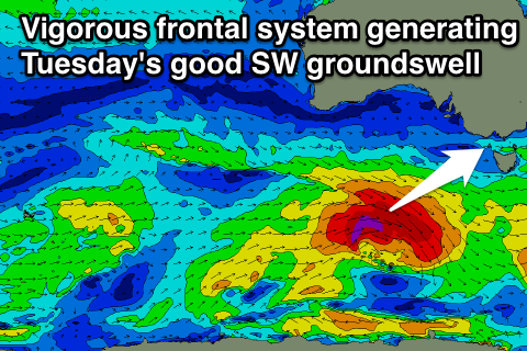
Our two good pulses of SW groundswell are still on track for next week with a vigorous and deepening frontal system pushing in from the south-west of WA this evening due to produce a fetch of fast tracking W/SW gales over the weekend.
This system was weakened a little, with the size from it being downgraded a touch to 3-4ft across the Surf Coast and 6ft+ on the Mornington Peninsula at its peak Monday morning.
The secondary system racing in close behind it will have more strength and is expected to produced a pre-frontal fetch of severe-gale W/NW winds followed by a tighter fetch of storm-force W/SW winds.
A strong long-period SW groundswell should be generated by this secondary system, arriving through Tuesday and pulsing to 3-5ft on the Surf Coast and 6-8ft on the Mornington Peninsula.
Conditions will be great Monday across the Surf Coast with a morning N/NW offshore (N/NE early on the Mornington Peninsula) before swinging W/NW late morning and onshore into the afternoon.
Tuesday will be good as well with more variable breezes (likely N'ly early) ahead of afternoon SE sea breezes.
Into Wednesday and the first day of the waiting period of the Rip Curl Pro, Tuesday's SW groundswell should drop away from 3ft to occasionally 4ft at swell magnets on the Surf Coast and 6ft+ on Mornington Peninsula under fresh and gusty N/NW tending NW winds (ahead of a possible late onshore change).
There's nothing major on the cards into the end of the week with smaller evels of swell and onshore winds in the wake of a change Thursday. More on this Monday though, have a great weekend!


Comments
Hi Craig,
Most of the information on this site (e.g. Surf Forecast Swell Train Analysis) suggests a SW wind tomorrow on the surf coast (even first thing). Do you still think that "conditions will be best on the Surf Coast tomorrow with a W/NW breeze through the morning"?
Cheers,
Hi J1m, yes the GFS model doesn't picking up the local effects we see from the Otway Ranges, which steers this onshore SW breeze around to the W/NW for a few hours after dawn around the Torquay region.
Same happened this morning, strong SW winds were forecast, but as I mentioned in Wednesday's notes, a lighter and short-lived W'ly breeze is likely around Torquay, and this was the case up until about 10am.
Hi Craig,
Just wondering if there are any signs of big swells for the second week of the holidays thanks
Unfortunately no Frenchy.
Nice topographical feature to have!
Hey craig do you think westernport surf at crunchies will be good tomorow thanks