Plenty of swell, with windows of good conditions
Victoria Forecast by Craig Brokensha (issued Friday 20th March)
Best Days: Saturday morning for keen surfers at selected spots, Sunday, early Monday morning east of Melbourne (from mid-late morning to the West), Wednesday morning both coasts
Recap
Small clean and easing 1-2ft waves across the Surf Coast yesterday with 2ft+ sets on the Mornington Peninsula under offshore winds that persisted most of the day ahead of an onshore change.
Today the beginners of a new W/SW groundswell was starting to show across both regions, with small clean 2ft waves around Torquay and bumpy 4-5ft sets on the Mornington Peninsula. Winds have since shifted onshore everywhere and we can expect the swell to kick solidly this afternoon/evening to 3-5ft on the Surf Coast and the 8ft range across the Mornington Peninsula.
This weekend (Mar 21 - 22)
This afternoon/evening's strong kick in W/SW and SW groundswells were generated by a vigorous frontal system pushing in from the west.
This front is now pushing across Tassie with a weakening fetch of SW winds trailing behind it, resulting in a steady drop in size from tomorrow morning, through the rest of the weekend.
The Surf Coast should still offer 3-5ft sets through the morning and 8ft sets across the Mornington Peninsula, but winds will be average and light to moderate from the S/SE, tending E/SE through the afternoon. There's an outside chance for variable winds at dawn on the Surf Coast, but don't count on it.
Sunday is the day to surf with developing offshore N/NE winds and an easing swell from 3ft on the Surf Coast and 4-6ft on the Mornington Peninsula. Early morning may still be a little unorganised, but conditions should be great from mid-morning.
 Monday onwards (Mar 23 onwards)
As touched on Wednesday, some very long-period SW groundswell is due to arrive Sunday afternoon/evening but it will have no size to it, generated in our far swell window around Heard Island.
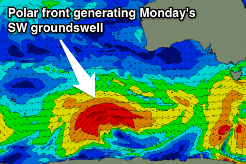
The secondary developments on the low that generated this long-period swell is of greater interest, with it positioned south-west of WA, generating a fetch of weakening gale to severe-gale W/SW winds through our swell window.
This system will push east today and tomorrow while slowly weakening, producing a moderate sized SW groundswell for Monday. The swell should build through the morning, peaking during the middle of the day to 3-4ft on the Surf Coast and 6-8ft on the Mornington Peninsula (smaller early).
You'll have to time your run though as fresh and gusty N/NW winds through the morning are due to swing W/NW late morning ahead of a strong W/SW change mid-afternoon.
So late morning/midday across the Surf Coast will likely be the best time to surf.
This change will produce an additional moderate plus sized SW swell for Tuesday, as it directs a fetch of S/SW gales through our swell window as it pushes towards us Monday.
The models are combining this new swell and the SW groundswell already in the water, over-forecasting the size for Tuesday morning, with the Surf Coast likely to be in the 3-5ft range and Mornington Peninsula 6-8ft.
Winds will be poor with a fresh to strong but easing SW'ly, with an outside chance of early W'ly breezes around Torquay at dawn.
Wednesday should be much better with local offshore winds and a dropping swell from 3ft and 5-6ft respectively.
Into the end of next week we should see moderate amounts of SW groundswell into Thursday but winds are a little tricky with a deepening mid-latitude low possibly stalling just to our west. We'll have a closer look at this on Monday though. Have a great weekend!


Comments
Hi when are your thoughts on when the next major swell will be about. Next weekend?
How big are we talking Willi and where.
Monday midday onwards and into Tuesday morning will be considerable but with average winds.
I'm talking around 4 ft with a few days of clean winds at jan juc area
I'll be impressed if the MP gets reported as >6ft tomorrow, this arvo might've been 5ft max I reckon.
Heard one break in 6-8ft this morning and it doesn't cop the brunt of the swell Mitch. Buoy readings are solid as well.
Easy 6ft sets today. Couple of bombies breaking well this morning and they don't start until it's 6-8ft
Fair enough. Didn't go in the water but Gunamatta def didn't look 6-8ft yesterday at 6pm . More searching to do so can't wait for tomorrow!
Tomorrow should be good, low tide in the morning so beachies will probably be closing out but could be a couple of sneaky reefs working
Cheers goofyfoot, probably head a bit further east
And that might apply to next weekend too, further further East, lookout Morris! :p
Are you living in Vic now MitchVG?