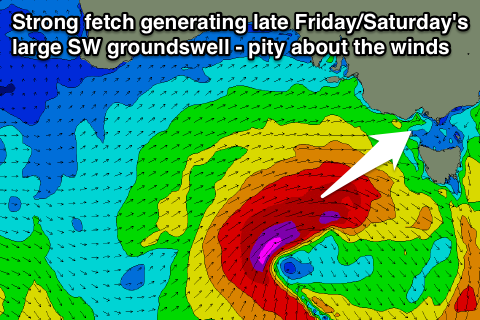
Plenty of swell later Friday and Saturday but with onshores
Victoria Forecast by Craig Brokensha (issued Wednesday 20th March)
Best Days: Thursday morning exposed breaks, Sunday both coasts
Recap
A small weak swell yesterday under average winds early, but conditions improved across both regions through the day as a fresh N/NE'ly developed.
Today a new inconsistent SW groundswell has peaked early with 2-3ft sets around Torquay under offshore winds, and bigger bumpier waves to the east.
The swell should ease through the day as winds swing more W'ly.
 This week and weekend (Mar 19 - 22)
Today's kick in inconsistent SW groundswell will ease this afternoon and further tomorrow leaving tiny waves across the Surf Coast and inconsistent 2-3ft sets across the Mornington Peninsula but with favourable N/NE winds early. A shift to N/NW winds is then due through the day ahead of a late W/SW change.
Friday will start small and weak with a short-range W/SW swell coming in around 2ft on the Surf Coast and 4-5ft on the Mornington Peninsula ahead of a larger increase in W/SW groundswell through the afternoon and evening.
The frontal system generating these swells is currently south of WA and will push through the Bight this evening before re-intensifying south-west of us tomorrow, aiming a fetch of gale to severe-gale W/SW winds through our swell window.
Two pulses of swell are due, a smaller and inconsistent W/SW groundswell and now better aligned SW swell.
Both are due to arrive around the same time on Friday afternoon, building to 3-5ft on dark across the Surf Coast and 8ft or so on the Mornington Peninsula before peaking overnight and easing Saturday from a similar size range.
Winds, as touched on Monday will be poor though around the peak of the swell with fresh SW winds through Friday (that may tend W'ly for a period through the morning around Torquay) and then light to moderate S/SE tending SE winds into Saturday.
This will leave no real options at all for a decent surf.
Sunday will be the day to surf and more so across the beaches on both coasts with the swell easing from 3ft or so on the Surf Coast and 4-6ft on the Mornington Peninsula.
Winds are expected to hold from the N/NE most of the day with the chance of late E/SE sea breezes.
Next Monday onwards (Mar 23 onwards)
A new pulse of long-range SW groundswell that was on the cards for Sunday afternoon has been pushed back to Monday and more so the afternoon when winds will go onshore.
During today an intense but small polar low is forecast to develop under the Heard Island region, producing a fetch of severe-gale to storm-force W'ly winds in our far swell window.
This low will then slow down but broaden a touch south-west of WA tomorrow resulting in the long-period but size-less swell to propagate towards us, arriving through Sunday afternoon/evening but with no major size.
A better and also inconsistent swell is due off the low once it slows down, arriving through Monday and building to 3ft to occasionally 4ft across exposed breaks into the afternoon on the Surf Coast and 6ft+ on the Mornington Peninsula.
Unfortunately morning offshore N'ly winds are due to give way to a strong SW change around midday, spoiling the new building swell while also providing a reinforcing short-range SW swell for Tuesday.
Winds are likely to improve Tuesday around Torquay with an approaching front kicking them around to the W/NW, while everywhere else looks to see W/SW breezes.
Longer term the outlook remains positive with moderate amounts of SW groundswell likely through the rest of next week, but we'll have a closer look at this on Friday.


Comments
Hi Craig,
Do you know the approximate timing of the SW change on Fri in Torquay?
Thanks
Truda, I'd say winds will likely swing from a morning W/NW'ly around Torquay, to the SW around 10am.
Swell will be quite weak, short-spaced amd mixed up though so don't expect anything special.