Surf Coast the go from Wednesday
Victoria Forecast by Craig Brokensha (issued Monday 2nd March)
Best Days: Wednesday on the Surf Coast (biggest late in the day), early Thursday protected spots on the Surf Coast, early Friday around Torquay, Saturday Surf Coast, Sunday morning Surf Coast
Recap
Saturday was great east of Melbourne with a clean easing 3ft to occasionally 4ft of swell while the Surf Coast was a slow and small 1ft to occasionally 2ft.
Winds remained favourable across both coasts until late afternoon ahead of a gusty S/SW change on dark.
Sunday was poor with onshore winds and a building windswell but come today, the windswell was easing from 2ft on the Surf Coast and 3-4ft on the Mornington Peninsula under much better N'ly breezes.
This week (Mar 3 - 6)
As touched on last update, tomorrow will be a lay day with a tiny leftover swell and light variable winds generally from the S/SW. A new SW groundswell is due to build through the day though, generated over the weekend and into today by a broad but relatively weak polar front pushing in under the country. This should produce an increase to 2-3ft late afternoon on the Surf Coast and 4-5ft on the Mornington Peninsula but with a moderate to fresh SW'ly wind.
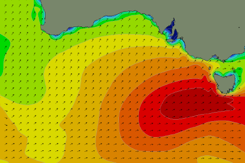
Of greater importance are the stronger pulses of groundswell due into Wednesday afternoon and Thursday owing to a strong node of the Long Wave Trough moving in from the west and across us Tuesday evening.
 Wednesday morning is expected to start a little slow as we fall in between swells, with 2-3ft waves on the Surf Coast and 4-6ft sets on the Mornington Peninsula. A strong new W/SW groundswell should fill in through the late morning though and further into the afternoon, generated by a strengthening frontal system projecting a fetch of W/SW gales through our western swell window tomorrow.
This should produce a moderate sized W/SW groundswell that is expected to build to 3-4ft late on the Surf Coast (with the odd 5ft set likely on dark across swell magnets) and 6ft to nearly 8ft surf on the Mornington Peninsula.
Right on the tail of Tuesday's frontal system will be a couple of secondary slightly weaker systems, projecting a fetch of better aligned SW gales up into us Wednesday with a secondary push through Thursday. These secondary systems will be acting on an already energised sea state, helping to produce a larger SW groundswell for Thursday.
Size wise, the Surf Coasy should come in at 4-6ft with 8ft+ sets on the Mornington Peninsula, persisting all day and only starting to ease Friday morning from 4-5ft and 6-8ft respectively.
Under these frontal progressions, the best surfing options are limited to the Surf Coast and other protected breaks like Western Port east of Melbourne and this will be the case from Wednesday. We should see fresh and strengthening W/NW winds all day across the Surf Coast Wednesday, with Thursday looking dicey now as one of the swell producing fronts pushes through. This will likely result in fresh to strong W/SW winds for the most part, with a period of early W'ly winds likely around Torquay, but it will be far from excellent and perfectly lined up.
Friday morning should see an early W/NW'ly around Torquay but this will again shift onshore by mid-late morning from the W/SW.
This weekend onwards (Mar 7 onwards)
Saturday is looking super fun across the Surf Coast and better east of Melbourne as the SW swell continues to ease from 3-4ft and 6ft+ respectively under morning N/NW winds ahead of a shift to the W through the day.
Some good new SW groundswell energy is then expected from Sunday afternoon through early next week as a couple of strong and pro-longed polar fronts develop in the Heard Island region, push along the Antarctic Shelf and then swing up into us over the weekend.
Winds are a little iffy, but we'll have a closer look at this on Wednesday.


Comments
Hi Craig,
just wondering if you are able to say anything more about the timing of the SW wind on Fri around Torquay - do you think it will stay offshore until 10-11? The wind have been changing around 9 lately which is no good for me!
thanks heaps!
Hi Truda, 10-11am is probably around the mark for Friday.
I'd say it should be still W'ly at 10am but then probably W/SW by 11am.
Thanks so much Craig, just enough time for me!