Average days ahead, improving from Thursday
Victoria Forecast by Craig Brokensha (issued Monday 16th February)
Best Days: Thursday morning east of Melbourne, Friday morning both coasts, Saturday morning both coasts, early Sunday Surf Coast
Recap
Small waves with clean conditions under light variable winds Saturday morning and then N/NE winds Sunday favoured locations east of Melbourne over the Surf Coast which was more ideal for beginners.
This morning the swell has bottomed out under early light winds on the Surf Coast and fresh onshore breezes to the east, which have since backed off again. We should see a new increase in W/SW groundswell through the afternoon/evening but not to the size expected on Friday as the forecast deepening of the incoming low right off our doorstep, has failed to eventuate.
Instead we'll likely just see a small to moderate kick across both coasts with onshore SW winds.
 This week and weekend (Feb 17 - 22)
Although this afternoon's and tomorrow's W/SW groundswell has been downgraded a touch in size, there was never going to be any quality waves on offer with onshore winds due through the coming days.
A moderate S/SE'ly is due tomorrow with 2-3ft sets on the Surf Coast and 4-6ft waves on the Mornington Peninsula, while Wednesday will be smaller and worse with a fresher S/SE'ly.
A new long-range and very inconsistent SW groundswell due through Thursday and Friday with improving winds is still on track.
This swell was generated over the weekend by a strong and slow moving polar low in our far swell window south-west of WA. The polar low generating the swell is now weakening, leaving an inconsistent and fun sized SW groundswell to arrive through Thursday, peaking during the afternoon and tail off slowly Friday morning.
The Surf Coast is only due to offer very infrequent 2-3ft sets during the afternoon at exposed breaks like 13th Beach, with 4-6ft waves on the Mornington Peninsula. Winds will only be workable at selected protected breaks to the east though with a morning E/NE breeze before afternoon S/SE'lys kick in.
Friday morning will be smaller and around 2ft and 3-5ft respectively under better N'ly breezes before afternoon sea breezes kick in.
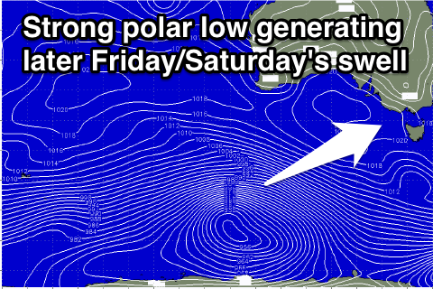
Into the late afternoon/evening Friday a secondary stronger and slightly larger SW groundswell is due across the state, generated by another strong polar low firing up to the south-west of WA but pushing further east with more strength than the last system.
This should produce a better 3ft+ of SW groundswell for later in the day Friday on the Surf Coast with 6ft+ waves on the Mornington Peninsula.
Saturday morning should provide a touch less size with a dropping swell under good N/NE offshores winds. Sunday looks smaller and with early W/NW winds on the Surf Coast.
Longer term we've got some good swell potential on the way for next week as a strengthening node of the Long Wave Trough moves in from the west this weekend and stalls just west of us into early next week.
This will likely project a vigorous and slow moving polar low right through our south-western swell window generating a series of strong SW groundswell pulses, but check back here on Wednesday for an update on this.

