Fun weekend, great early Monday
Victoria Forecast by Craig Brokensha (issued Friday 26th December)
Best Days: Saturday morning Surf Coast, Sunday morning east of Melbourne. Monday morning both coasts, Tuesday and Wednesday mornings Surf Coast
Recap
Some good waves were seen across the state yesterday morning with a peak in new SW groundswell to 3ft on the Surf Coast and the inconsistent 6ft+ range on the Mornington Peninsula with light variable winds. Onshores kicked in from late morning and slowly strengthened ahead of a more noticeable onshore change mid-afternoon.
Today a secondary slightly stronger pule of W/SW groundswell has filled in this morning with 3-4ft sets on the Surf Coast and 6-8ft waves on the Mornington Peninsula, but the Torquay region was the only option early with a W/NW breeze. Strong onshores have since kicked in writing off the surf for the rest of the day.
This weekend (Dec 27 - 28)
This morning's pulse of W/SW groundswell should start to ease off through this afternoon and then further through tomorrow from the 3ft range on the sets across the Surf Coast and 6ft on the Mornington Peninsula.
Winds will be much better for the Surf Coast and be offshore from the W/NW tomorrow morning, while the Mornington Peninsula will be average.
Sunday morning is now looking a touch bigger than it was on Wednesday with the strong SW groundswell due through the day arriving a touch earlier.
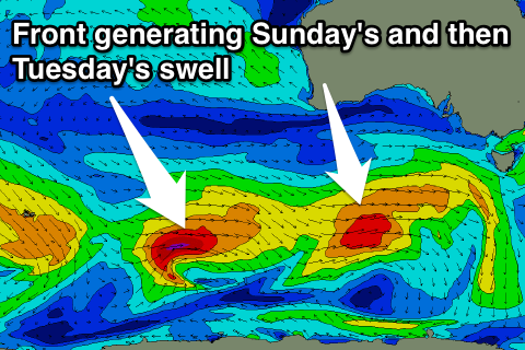
 The frontal system generating this swell is currently moving up towards us from well south of WA, aiming a fetch of broad W/SW gales through our swell window.
The swell is due to build from 2-3ft Sunday morning on the Surf Coast to 3-4ft through the afternoon, with the odd bigger bomb possible near dark. The Mornington Peninsula looks to build from 4-5ft to 6ft to occasionally 8ft near dark.
Winds will favour locations east of Melbourne with a morning NE'ly, possibly tending N/NE before SE sea breezes kick in.
Monday onwards (Dec 29 onwards)
Sunday's swell is expected to start easing through Monday, but a secondary vigorous polar front pushing in closely behind it over the coming days should generate a reinforcing pulse of W/SW groundswell for Tuesday morning.
Size wise the Surf Coast should ease a touch from 3ft+ early Monday and then ease from around 3ft+ on the sets through Tuesday morning. The Mornington Peninsula will be bigger and easing from the 6ft range Monday morning, holding around 6ft on the sets Tuesday morning.
Winds will be good for both coasts early Monday and locally offshore (N/NE Mornington Peninsula and N/NW Surf Coast) ahead of a gusty SW change mid-afternoon.
Tuesday will then see W/NW tending W/SW winds on the Surf Coast and terrible conditions to the east.
Tuesday's change will be related to a weakening cold font pushing into us and with this we're not expected to see any major size, with the Surf Coast holding 2-3ft on Wednesday with 4-6ft waves on the Mornington Peninsula before easing into the end of the week.
Winds should swing from the W/NW to W/SW again on Wednesday but with less strength than Tuesday while Thursday should see more variable winds early opening up more options east of Melbourne.
Longer term there's no major swell on the cards so make the most of the coming period! Have a great weekend.

