Fun weekend, small windows next week
Victoria Forecast by Craig Brokensha (issued Friday 19th December)
Best Days: Saturday morning Surf Coast, Sunday morning both coasts, early Monday for keen surfers east of Melbourne, Tuesday morning
Recap
The W/SW swell remained a touch below forecast expectations into yesterday to 2ft for the most part on the Surf Coast, although swell magnets like Bells and Winki picked up the odd expected 3ft wave. Conditions were good all day with light N/NW winds ahead of a freshening W/NW'ly that tended variable mid-afternoon and then onshore into the evening.
The Mornington Peninsula was fun and clean in the 3-5ft range at dawn before winds quickly tended W/NW.
Today a new W/SW swell has filled in but conditions are poor across all but protected locations on the Surf Coast where an early W/NW'ly is blowing. Waves were in the 2ft to sometimes 3ft range. Make the most of it as onshores will move in through the morning.
This weekend (Dec 20 - 21)
Today's lift in W/SW swell will ease off gradually over the weekend as winds improve for both coasts, best on the Surf Coast tomorrow and east of Melbourne Sunday.
The Surf Coast should ease from the 2ft+ range with 4-5ft sets on the Mornington Peninsula tomorrow morning under NW winds. The Mornington Peninsula may even see straighter N/NW breezes, but don't count on it.
Sunday morning will be the day to hit the beaches east of Melbourne as the swell drops back further from the 3-4ft+ range under N/NE winds. A shift to the NW is due through the afternoon ahead of a possible late SW change, so try and get out before lunch for the best of it. There is a chance winds go SE before the SW change keeping conditions workable into the afternoon. The Surf Coast will be clean on the beaches as well but easing from a small 2ft.
 Next Monday onwards (Dec 22 onwards)
Monday is looking a little dicey with a slow start and light lingering SE breeze in the wake of Sunday's onshore change. A small new SW groundswell should build through the day from a weak polar front projecting towards us over the weekend, but not above 2ft on the Surf Coast and 3-4ft+ on the Mornington Peninsula.
Tuesday will be the day to surf as the swell holds a similar size to Monday under early N'ly winds. A shift to the NW is due late morning ahead of a gusty W/SW change mid-afternoon so the early will be the pick east of Melbourne.
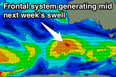
From Wednesday onwards we should see some more substantial swell across the state as a couple of stronger polar fronts fire up from the South West of WA and project north-east towards us.
An initial medium sized increase is due through Wednesday, building to 2-3ft on the Surf Coast and 4-6ft on the Mornington Peninsula before easing a touch through Thursday ahead of a secondary slightly stronger SW swell Friday.
Unfortunately winds look average and onshore Wednesday from the S/SE in the wake of Tuesday afternoon's change, with Thursday seeing variable winds from the SW (possibly W/NW around Torquay), before freshening from the W/SW through the day as the front linked to Friday's swell pushes through. This will see fresh SW winds continue into Friday creating poor conditions.
Longer term the Southern Ocean looks to remain active, generating good swells for the week running into the new year, but winds will be the main consideration. We'll look at this again on Monday. Have a great weekend!

