East of Melbourne Wednesday and Thursday
Victoria Forecast by Craig Brokensha (issued Monday 10th November)
Best Days: Wednesday and Thursday east of Melbourne
Recap
The Mornington Peninsula and other exposed coasts offered the best waves Saturday morning with early offshores and 3-4ft of swell, while the Surf Coast was a slow 1-2ft.
An onshore change moved through late morning writing-off the surf for the rest of the day, and as talked about on Friday, lingered into Sunday creating average conditions with a slight lift in size.
Today the Surf Coast was OK with a small clean 2ft of swell from yesterday, while the Mornington Peninsula was a bumpy and lumpy 3ft. We should see a new swell develop through the afternoon from the W/SW but winds will be poor and fresh and gusty from the SW.
 This week and weekend (Nov 11 - 16)
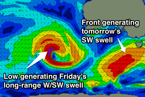
This afternoon's kick in W/SW groundswell will be linked to a pre-frontal fetch of W/NW winds pushing in ahead of a stronger low and better SW swell due tomorrow. This low is producing a fetch of SW gales through our swell window and should provide good 3-4ft+ waves all day tomorrow on the Surf Coast and 6ft to occasionally 8ft sets on the Mornington Peninsula but unfortunately winds will be poor and moderate to fresh from the S/SE in the wake of today's change.
Wednesday and Thursday will be the days to surf east of Melbourne, but it may be a little sizey still early Wednesday along the Mornington Peninsula and a touch lumpy. The Surf Coast should ease from 3ft or so, with 5-6ft sets on the Mornington Peninsula under light E/NE tending NE winds and then SE sea breezes.
Thursday morning should be straighter with a better N/NE breeze and fun waves easing from 3-4ft. The Surf Coast will be small and easing from 1-2ft.
The next increase in swell is due from the W/SW and will be quite inconsistent, coming from a strong but unfavourably tracking low from the west of WA down towards the polar shelf.
A fetch of severe-gale W/SW winds will be aimed towards us before the system weakens south of WA and aims a less than favourable fetch of S/SW winds towards the Bight.
A long-range W/SW groundswell will result, arriving through Friday morning and building towards a peak through the afternoon to an inconsistent 2ft to occasionally 3ft on the Surf Coast and 4-6ft on the Mornington Peninsula.
Winds will be average though with an early W/NW'ly on the Surf Coast, giving way to a S/SW change as a trough moves across us during the morning. This trough will be attached to some weak polar activity with some reinforcing SW swell due through Saturday and Sunday but to no major size and with onshore S/SW winds Saturday and possibly early W'ly winds Sunday.
Next Monday onwards (Nov 17 onwards)
There's nothing too major on the cards for next week, but small to moderate W/SW-SW swells pulses are due to continue at this stage. Winds look to be generally from the west on the building side of the swells and then NE on the easing, but we'll have a look at this again Wednesday.


Comments
How reliable is the "offshore-ness" of wednesday morning on phillip island? Mostly east with a hint of north from what i can find.
It looks to be at least E/NE, if not tending NE at a stage through the morning. Real light so there'll probably be some residual lump and wobble.
Thanks craig. Just moved down from qld, trying to learn all the new beaches and their quirks. completely different world down here swell-wise
Warhawk, it's called groundswell. That's what we get down here
Yep. And just swell in general. qld can send you crazy