Workable options over the coming days, bigger swell Tuesday with onshores
Victoria Forecast by Craig Brokensha (issued Wednesday 5th November)
Best Days: Thursday up until early afternoon Surf Coast, Friday both coasts, early Saturday Mornington Peninsula, Sunday morning both coasts for glassy/lumpy waves
Recap
Exposed locations across the state were the go yesterday with a small clean swell to 2-3ft east of Melbourne under persistent offshore winds.
A late onshore change has persisted into today but also brought with it a kick in swell with messy 2-3ft surf west of Melbourne and 3-4ft to the east.
This week (Nov 5 - 7)
We've got some better days ahead across both coasts into the end of the week, as a mix of long-range and shorter-range W/SW groundswells fill in.
Tomorrow will start off small but clean across the Surf Coast with sets to 2ft or so, and bumpy 3-5ft waves on the Mornington Peninsula, but a pulse in size is due during the day and into the afternoon. This will consist of a mix of long-range and inconsistent W/SW groundswell from the Southern Indian Ocean and a medium-range W/SW swell from a pre-frontal fetch of W/NW winds under the country.
The Surf Coast should see inconsistent sets approaching 3ft through the afternoon at exposed breaks with 4-6ft waves on the Mornington Peninsula.
A slow drop in size is then due through Friday from 2-3ft and 4-5ft+ respectively, although this will be slowed into the afternoon by a reinforcing W/SW swell arriving through the day.
Winds tomorrow will be offshore from the NW all morning and start to give way to a sea breeze early afternoon, therefore late morning and into midday will be the pick with the most size and best conditions.
Come Friday, the Mornington Peninsula will be the go (but the Surf Coast beaches will still be good) with a N/NE tending variable breeze (N'ly possibly tending N/NW at times on the Surf Coast).
This weekend onwards (Nov 8 onwards)
The weekend will start slow with leftover levels of swell from Friday with a short window of offshore N'ly winds across the Mornington Peninsula ahead of a shift to the NW through the morning ahead of a gusty W/SW change into the afternoon.
The Surf Coast is only expected to offer 1-2ft waves, while the Mornington Peninsula should see 3-4ft sets early.
This change will be attached to an intense mid-latitude low dipping south-east from the Bight aiming a tight fetch of gales towards us, but the unfavourable track will limit size and only a small 2ft+ wave is due across the Surf Coast with 3-5ft sets on the Mornington Peninsula Sunday.
Winds are likely to ease off rapidly overnight Saturday leaving light and variable winds Sunday morning that may tend locally offshore across the Surf Coast.
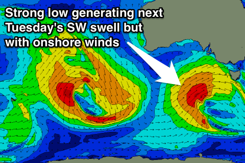
 A secondary longer-range increase in W/SW groundswell is due later Sunday and into Monday from a pre-frontal fetch of W/NW winds swinging in from the Southern Indian Ocean again. Of greater importance is a stronger trailing fetch of W/SW gales pushing into us producing a larger W/SW groundswell for later in the evening Monday, peaking Tuesday from the SW.
The initial W/SW swell should come in at 2-3ft on the Surf Coast and 4-6ft on the Mornington Peninsula Monday morning, while the larger SW groundswell Tuesday morning should come in at 4-6ft on the Surf Coast and 8ft+ on the Mornington Peninsula.
Winds at this stage look dicey with a fresh and gusty W/NW tending stronger W/SW breeze through Monday and then strong SW tending S/SW winds Tuesday as the low pushes across us, with only a short-lived period of early W'ly winds around Torquay.
Unfortunately on the backside of the swell we'll see SE winds Wednesday as a ridge of high pressure moves in, with better NE winds for the Mornington Peninsula Thursday, but this a long way down the track and will have to be reviewed Wednesday.

