Exposed spots Tuesday, both coasts Friday morning
Victoria Forecast by Craig Brokensha (issued Monday 3rd November)
Best Days: Exposed spots tomorrow, Surf Coast from mid-late morning Thursday, both coasts Friday morning, Mornington Peninsula Saturday morning
Recap
The weekend's wasn't too special as winds flirted from the West Saturday with 2-3ft of swell across the Surf Coast before a stronger W/SW change moved through the afternoon.
A solid increase was seen behind this change into Sunday with raw 4-5ft waves across the Surf Coast under early W'ly winds while the Mornington Peninsula was larger but a stormy mess.
Today a high has quickly moved in behind yesterday's onshores resulting in winds tending variable and locally offshore, but conditions were still quite lumpy and wobbly across both coasts and a little too solid east of Melbourne.
Winds will come up from the E/SE through the day as the swell eases, and we're already seeing this along the Surf Coast.
 This week (Nov 4 - 7)
Tomorrow morning is still looking super fun across the beaches east of Melbourne and other more exposed breaks across the state.
The weekend's swell will continue to ease under fresh N/NE winds along the Mornington Peninsula and N/NW winds on the Surf Coast, but with easing 3ft to occasionally 4ft sets east of Melbourne and 1-2ft waves to the west the decision won't be too hard.
Winds may tend variable into the afternoon ahead of a late change, and this change will persist into Wednesday with small amounts of swell under a fresh and gusty S/SW breeze.
A new long-range and inconsistent W/SW groundswell is due on Thursday and this is looking a touch better than it was on Friday with better levels of close-range W/SW swell in the mix.
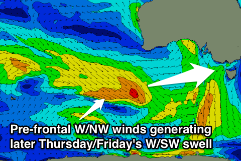
A series of pre-frontal W/NW winds pushing from the Southern Indian Ocean under WA will move through our western swell window, producing moderate pulses of W/SW groundswell.
The first will be mixed in with the long-range W/SW groundswell, building through Thursday and peaking during the afternoon. A secondary pulse is then due Friday morning ahead of final smaller pulse for Saturday.
Size wise, the Surf Coast should build to an inconsistent 3ft on the sets Thursday afternoon with 4-6ft waves on the Mornington Peninsula before easing from a similar but slightly smaller size Friday morning. Saturday will then be only in the 1-2ft range on the Surf Coast with 3-4ft sets on the Mornington Peninsula.
Winds on Thursday should be good for the Surf Coast before the swell really kicks with an offshore NW wind, but a shallow SW change is due into the afternoon.
Friday will be best east of Melbourne and on the beaches across the Surf Coast with a N/NE offshore ahead of SE sea breezes.
This weekend onwards (Nov 8 onwards)
With the smaller W/SW swell and strong N'ly winds ahead of a W'ly change, the Mornington Peninsula will be the go early in the day, while Sunday will be better on the Surf Coast with a small bump in close-range W/SW swell and morning offshore breezes.
Longer term we may see a better SW groundswell developing for early next week from a stronger polar front pushing up towards us Sunday, but we'll review this Wednesday.

