Average weekend, improving Monday, best on beaches Tuesday morning
Victoria Forecast by Craig Brokensha (issued Friday 31st October)
Best Days: Saturday morning protected spots on Surf Coast, early Sunday keen surfers around Torquay, Monday morning, Tuesday morning east of Melbourne
Recap
Yesterday was super fun across the Surf Coast with a drop in swell back to 3ft+ under morning offshores before weak sea breezes kicked in. The Mornington Peninsula was bumpy and average with the west in the wind.
Today, a strong pulse of SW groundswell has come in as expected with 3-5ft sets across the Surf Coast and 6ft to occasionally 8ft waves on the Mornington Peninsula under excellent local offshore winds. This has created great conditions right across the state, but the size was unfortunately too big for the beaches along the Mornington Peninsula.
We should see this morning's SW groundswell ease back during the day as winds persist from the N'th across the Mornington Peninsula and N/NW on the Surf Coast.
 This weekend (Nov 1 - 2)
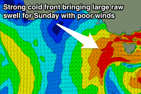
The weekend will see plenty of swell, especially into Sunday but conditions will be poor with only short-lived windows of clean conditions around Torquay both mornings.
Today's kick in strong SW groundswell will back off back to the 3ft range tomorrow morning across the Surf Coast with early fresh to strong W/NW winds ahead of a shift to the W/SW through the day.
This change will be linked to a strong polar front pushing up and into us, with a late kick in short-range swell expected to be followed up by some stronger groundswell due Sunday.
Size wise we're looking at 4-5ft+ waves on the Surf Coast Sunday with 8ft+ storm surf on the Mornington Peninsula with poor strong but easing SW winds across all locations. The Torquay region should see an early W'ly at dawn, but conditions will still be quite raw and unorganised, and it's probably not worth the trip from Melbourne.
Next week onwards (Nov 3 onwards)
In the wake of Sunday's easing onshore change, a high pressure system will move in really quickly from the west, resulting in winds tending variable and even light offshore from the N/NE across the Mornington Peninsula Monday morning. The swell will still be quite wobbly and lumpy from the overnight onshores, and the size likely a little too solid for the beaches east of Melbourne, easing from 6ft+.
The beaches on the Surf Coast should be workable but wonky and lumpy with an easing 3-4ft of swell.
Tuesday will be the pick of next week though east of Melbourne as the swell drops from 3-4ft on the beaches under fresh N/NE tending E/NE winds. The Surf Coast will be small to tiny but ideal for beginners.
The rest of next week isn't looking too flash unfortunately with an onshore change and tiny swell due on Wednesday, while a new long-range W/SW groundswell due into Thursday expected to be met with poor S/SE tending E/SE winds.
This swell won't have much size or strength in any case, generated by a relatively weak and unconsolidated cold front pushing up towards WA this weekend and then through the Bight while breaking down early next week.
The Surf Coast should reach 2ft+ in Torquay with 2-3ft sets at 13th Beach Thursday afternoon, while the Mornington Peninsula should see inconsistent 4-6ft sets.
Friday will be better across the Mornington Peninsula but not great as the swell eases under fresh to strong E/NE winds.
Longer term the outlook is grim, with only small to moderate pulses of swell expected and with poor S/SW winds. Therefore make the most of today's waves!! Have a great weekend.

