Fun weekend of surf, OK but inconsistent next week
Victoria Forecast by Craig Brokensha (issued Friday 12th September)
Best Days: Saturday morning and Sunday morning both coasts, Monday morning at spots that like a NE wind, Wednesday morning west of Melbourne
Recap
New levels of W/SW swell started to show yesterday morning coming in at 3-4ft across the Surf Coast and 6-8ft on the Mornington Peninsula under fresh W/NW winds. A stronger increase in W/SW groundswell was seen during the afternoon, reaching 5ft across most exposed breaks on the Surf Coast, a touch under the expected pulse to 5-6ft+ as winds tended cross-onshore from the W/SW. The lack of stronger 6ft sets look to be a result of my concerns Monday where the frontal system tracked a little too quick and ahead of itself, somewhat escaping the swell it was generating.
Still, this morning offered good fun waves on the Surf Coast with clean 5ft sets at Bells and Winki, while the Mornington Peninsula was a bumpy and large 8ft. The swell should ease through the day as winds tend onshore but without too much strength.
This weekend and next week (Sep 13 - 19)
Today's swell should continue to back off into tomorrow, but a reinforcing W/SW swell should keep inconsistent 3ft+ waves hitting the Surf Coast most of tomorrow before easing slowly from an inconsistent 3ft Sunday. The Mornington Peninsula should still be in the 5-6ft+ range, dropping from 5-6ft into Sunday.
Winds should be great for the Surf Coast and workable on the Mornington Peninsula tomorrow morning with a NW breeze (N/NW east of Melbourne) before weak onshores develop into the afternoon. Sunday should play out similarly as the swell eases.
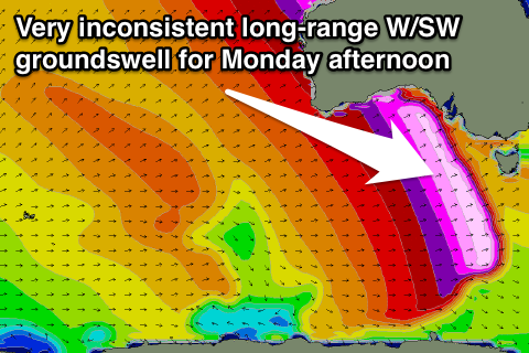
 Monday is expected to start off slow with inconsistent 2-3ft waves on the Surf Coast and 4-5ft sets on the Mornington Peninsula but a very inconsistent but strong long-range W/SW groundswell should fill in through the day.
This has been generated in the Southern Indian Ocean, in our very far swell window, but the size and strength of the swell should still see it making its way towards us, filling in through the day Monday.
The Surf Coast should peak at a very inconsistent 3ft from midday onwards, with the odd bigger 4ft bomb at swell magnets such as 13th Beach, but the waits between sets will probably be in the 10-15 minute range. The Mornington Peninsula should offer infrequent 6ft+ sets at the swells peak, and winds will be best for this region with a light NE breeze ahead of a shift to the SE into the afternoon.
The swell should ease back through Tuesday under funky S/SE tending SW winds (but without too much strength).
Into Wednesday another smaller long-range and very inconsistent W/SW groundswell is due from the Southern Indian Ocean but this swell is only likely to offer infrequent 2-3ft sets on the Surf Coast into the afternoon with 5-6ft waves on the Mornington Peninsula. Winds look as if they'll remain funky with an early W/NW tending SW breeze, creating bumpy conditions as the swell builds through the day.
Into the end of the week there's still nothing major on the cards, with a blocking setup to our west putting a cap on any major swells being generated, while we may see winds from the east as a surface trough deepens off the East Coast, but more on this Monday. Have a great weekend!

