Large building swell tomorrow, cleanest Friday as it eases
Victoria Forecast by Craig Brokensha (issued Wednesday September 10th)
Best Days: Thursday morning, Friday morning, Saturday morning, Sunday morning
Recap
The surf was effectively flat on the Surf Coast yesterday, while the Mornington Peninsula offered clean 2ft waves during the morning before winds tending NW and then variable into the afternoon.
Today a new acute W'ly swell has come in across both coasts with waves in the 2ft range with the odd bigger sets on the Surf Coast, while the Mornington Peninsula was in the 4-5ft+ range. Conditions were best west of Melbourne though with a fresh and gusty W/NW breeze. A drop in size is due into the afternoon as winds tend more NW.
This week and weekend (Sep 11 - 14)
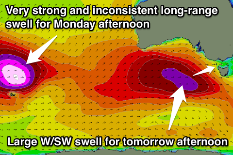
The large W/SW groundswell due tomorrow is still on track, with the vigorous frontal system generating this swell currently positioned south of the Bight, with a weakening fetch of severe-gale to sub-storm-force W/SW winds being aimed towards us.
This front will push through tomorrow morning and the bulk of the swell will follow behind it.
 Early in the morning when winds should be favourable but strong from the W/NW the swell is only expected to be in the 3-4ft range across the Surf Coast and 6ft+ on the Mornington Peninsula.
The swell should kick solidly through the day though as winds swing to the W/SW, reaching 5-6ft+ on the Surf Coast into the afternoon and 10ft on the Mornington Peninsula.
Friday will be much better though as the swell remains large early under NW winds. The Surf Coast should ease from 5-6ft, with 8ft+ sets on the Mornington Peninsula, easing steadily through the day back to 3-5ft and 6-8ft respectively as winds tend SW.
A reinforcing W/SW swell is due on Saturday, stopping the easing trend, generated by a secondary smaller and much weaker front pushing in on the tail of the main swell generating storm.
This should keep the Surf Coast kicking in the 3ft+ range with 5-6ft+ sets on the Mornington Peninsula Saturday before easing a touch into Sunday.
Winds should be great for the Surf Coast Saturday and workable east of Melbourne with NW tending W/SW breeze (N/NW on the Mornington Peninsula). Sunday will only be good for a short period with an early fresh NW'ly ahead of a gusty SW change during the morning, so get in early!
Next week onwards (Sep 15 onwards)
Into Monday conditions will unfortunately remain poor across the Mornington Peninsula with an easing onshore S/SW breeze, while the Surf Coast may see an early W'ly around Torquay.
A new long-range and very inconsistent but large-period W/SW groundswell is due to fill in and peak through the afternoon though, currently being generated in the Southern Indian Ocean by one of the strongest polar storms we've seen this year.
A fetch of severe-gale to storm-force W/SW winds are generating an open ocean sea state of around 60ft, with the swell periods associated with this swell expected to reach out to 24-25s.
This is a very long way away from us, and there'll be considerable swell decay, but the swell still arrive through Monday in the medium size range but be extremely inconsistent.
The Surf Coast is expected to hold in the 3ft range with the odd 4ft bomb at swell magnets into the afternoon, while the Mornington Peninsula should build to 6ft+ through the day.
A slow drop in size is due into Tuesday and winds should tend variable, but we'll review this again Friday.


Comments
Hi Craig,
Has this swell kicked a little later than forecast? PN buoy showing the first signs of 16 sec period @ 11am. Model calls it coming through much earlier. Only looking at the cams but don't think it looks 5-6ft on the surfcoast just yet.
Maybe a touch, but I expected it to build through the afternoon, buoys looking good now and it's probabyly 5ft on the Torquay reefs now.
Tomorrow morning looking great!
Models had 4ft in the morning the last few days, but combined the building short-range swell and groundswell this morning, hence over-forecasting the size to 6ft today, which is annoying.
Tricky for the Wave Watch model to resolve these frontal systems that push close to Vicco along with the swell its generating.
Ahhh, good one. Thanks Craig!