Surf Coast the go all week
Victoria Forecast by Craig Brokensha (issued Monday 4th August)
Best Days: Tuesday, Wednesday, possibly Thursday morning, Friday, Saturday
Recap
One final large pulse of W/SW groundswell filled in late Friday and held well into Saturday morning with lumpy 6ft sets across the Surf Coast under light W/NW tending variable winds.
Sunday was much cleaner and straighter though with a smaller 3ft of groundswell and offshore NW winds. The Mornington Peninsula saw a morning N'ly creating clean conditions with a solid 5-6ft of groundswell across the beaches.
Today the swell has dipped back and bottomed out to 2ft on the Surf Coast and 3-4ft on the Mornington Peninsula as NW winds continued to favour locations west of Melbourne. We should see a slight kick in long-range W/SW groundswell this afternoon as winds swing more W/NW.
This week and weekend (Aug 4 - 10)
This afternoon's increase in long-range and inconsistent W/SW groundswell will be replaced by a couple of better and more consistent W/SW groundswells through tomorrow morning and late afternoon.
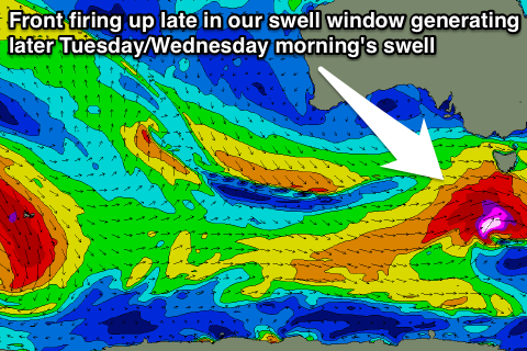
An initial pulse of swell for tomorrow morning has and is still being generated by a tight polar front racing in under the country the last day or so. This system is currently pushing under Tassie, but right behind it a secondary strong polar front is firing up late in our swell window, pushing across Tassie early tomorrow morning.
 An initial increase in W/SW groundswell should be seen tomorrow morning to 3-4ft on the Surf Coast and 6ft+ on the Mornington Peninsula ahead of a secondary late increase in swell with 5ft and 8ft sets expected respectively.
Winds will be best west of Melbourne tomorrow with a fresh NW tending W'ly breeze, with an outside chance of a swing to the W/SW into the late afternoon.
Into Wednesday the swell should slowly dip away and with this strengthening W/NW winds will again favour the protected reefs on the Surf Coast.
With this front we should see a renewal of W/SW groundswell energy late in the day from an unfavourable but broad fetch of W/NW gales, and this should hold into Thursday morning to 3-5ft on the Surf Coast and 6-8ft on the Mornington Peninsula.
A drop in size is due into the afternoon, but come Friday a better S/SW groundswell from the base of the front is due to fill in. This swell produced by a fetch of severe-gale SW winds south-southwest of Tassie should keep 3-4ft sets hitting the Surf Coast and 6ft+ lines on the Mornington Peninsula through the morning before easing later and further into the weekend.
Winds may be be a little funky Thursday morning with the passing of the frontal system, with a moderate but easing S/SW'ly while Friday looks clean again with offshore N/NW winds.
Saturday will be the best time to head to the Mornington Peninsula with a straighter N'ly breeze likely through the morning ahead of a shift to the N/NW into the afternoon.
A low point in activity is due on Sunday morning, but into the afternoon a new long-range SW groundswell is due. This will be generated by a vigorous polar frontal progression firing up west of Heard Island today and then moving slowly east through the entire week before weakening south of the country through Friday and Saturday. A continuous fetch of gale to severe-gale W/SW winds will be aimed towards us generating a large groundswell for WA and Indo, with a touch less size for us.
A medium to large sized and very inconsistent long-range SW groundswell should result, pushing in strongly later Sunday to 4-5ft on the Surf Coast and 8ft on the Mornington Peninsula. A peak should be seen Monday morning, topped up with a local front pushing up into Tassie on Sunday with 4-6ft and 8ft+ surf expected respectively. Winds will be an issue though with a strong S/SW change due through Sunday before lunch with lighter S/SW winds likely into Monday morning. We'll review this again on Wednesday though.

