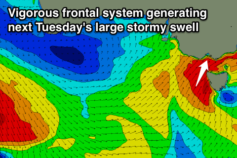
Good next few days, large and stormy next Tuesday along with snow
Victoria Forecast by Craig Brokensha (issued Wednesday 18th Jun)
Best Days: Thursday, Friday, Saturday, early Sunday
Recap
A new short-range W/SW swell filled in yesterday and the Torquay region performed the best with early light W'ly winds but conditions were still a little bumpy/lumpy. The Mornington Peninsula was a write off with fresh onshore winds and a larger stormy swell.
Today the swell is easing slowly but conditions are much cleaner with a light NW wind and this should tend more variable into the afternoon, providing improving conditions east of Melbourne.
This week and weekend (Jun 18 - 22)
As touched on in Monday's notes, a mix of long-range and very inconsistent W/SW groundswell along with a better SW groundswell are due across both coasts tomorrow ahead of a reinforcing W/SW groundswell Friday.
The best pulse tomorrow has been generated by a healthy polar front the last couple of days and should provide good 3ft sets across the Surf Coast with 5-6ft waves on the Mornington Peninsula.
Friday's reinforcing W/SW groundswell is due to be a touch smaller and less consistent to 2-3ft and 5-6ft respectively.
Winds tomorrow should be favourable for a wide variety of locations with a fresh N/NW tending N'ly breeze on the Surf Coast and persistent N/NE winds on the Mornington Peninsula.
Come Friday winds are due to persist from the N/NW all day but will probably tend straighter N'ly at times east of Melbourne.
Into the weekend the swell should slowly dip away from the W/SW, from 2ft+ or so on the Surf Coast Saturday and 2ft Sunday on the Surf Coast (slightly under the model forecasts as it looks like Wave Watch is over-forecasting a W/SW swell developing in the Bight this evening and tomorrow as well as a long-range W/SW groundswell). The Mornington Peninsula should offer inconsistent but good 3-5ft waves Saturday and Sunday morning.
Winds on Saturday are expected to persist from the N/NW before tending variable into the afternoon, favouring the Surf Coast and western end of the Mornington Peninsula. Sunday should see winds holding from the N/NW all day as the swell drops away.
Next Monday onwards (Jun 23 onwards)
Monday will be a day to miss with tiny amounts of swell and strong to gale-force N/NW winds ahead of a W'ly change linked to a vigorous frontal system moving in from the west.
As touched on last update, the models were divergent on the strength, make-up and intensity of this system but now they're starting to firm up.
What we'll see is a mid-latitude frontal system pushing in from WA, feeding off a deep pool of cold air in the upper atmosphere resulting in the system deepening significantly while pushing across us.
 This will see a fetch of gale to severe-gale SW winds projected up into us Monday evening and through Bass Strait Tuesday kicking up a large and stormy S/SW swell along with a good dump of snow in the alpine regions.
Size wise we're probably looking at stormy 6ft waves on the Surf Coast developing through Tuesday with 8-10ft surf on the Mornington Peninsula but with gale-force SW winds.
The weather system is expected to push off into the Tasman Sea on Tuesday evening resulting in a drop in size through Wednesday. The models diverge on a possible secondary system firing up towards us during the middle of next week, generating a reinforcing swell with more favourable winds, but we'll discuss this Friday.


Comments
Hi Craig, do you think there's any chance of nw winds Tuesday morning on the west coast?
Looking more than likely from the W/NW goofy, but models still divergent on whether it will go NW.
Problem is, is that there won't be much swell until winds go onshore, as the front is bringing the swell with it. Possiblity for Wednesday having morning W'ly winds, but models still a bit all over the place. Hopefully it will firm up a bit tomorrow.