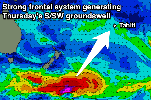
Strong easing S/SW swell, new pulse for Thursday, with moderate N/NW swell for the north
Tahiti forecast by Craig Brokensha (issued Sunday 6th March)
Best Days: South West facing breaks all this period, North Coast Sunday through Friday
This week and next (Mar 7 - 18)
South West Coast: A large increase in S/SW groundswell today (Saturday) should continue into tomorrow morning before easing back from the 6-8ft+ range across exposed breaks further from the S'th Monday under moderate to fresh E/SE trades.
Small background surf in the 3-4ft range is due Tuesday morning ahead of a slight kick in new S/SW groundswell through the afternoon, easing Wednesday.
 Of greater importance is a stronger polar frontal progression that's developed south-west of Tassie and has pushed east past the Tasman Sea and while generating a fetch of gale to severe-gale W/SW winds. This system is now south-east of New Zealand with core wind speeds reaching the storm-force range, producing a strong long-period S/SW groundswell.
The fore-runners are due to arrive Wednesday afternoon, with the bulk of the swell due to peak Thursday morning 6-8ft+ across exposed breaks, easing back later and further through Friday from 6ft+ and more noticeably Saturday.
This easing trend will be slowed a little by a reinforcing S/SW groundswell produced on the tail of the main progression by an additional fetch of W/SW gales.
Conditions are looking good with moderate to fresh E/NE trades, continuing through most of next week while easing.
A couple of small embedded low firing up past New Zealand should produce moderate S/SW groundswell pulses from Sunday through most of next week, mainly in the 4-6ft range across exposed breaks. Biggest Sunday, later Tuesday and Wednesday morning with each pulse.
North Coast: A flurry of strong storm activity through the North Pacific Ocean the last couple of days and then over the coming days will generated a couple of pulses of inconsistent N/NW groundswell.
The largest is due tomorrow, offering infrequent 5-6ft sets across exposed breaks, with the chance of the odd bigger bomb, easing back through Monday and Tuesday.
The next increase is likely Wednesday afternoon and Thursday morning with 4-5ft sets due, easing back off through Friday and further into the weekend and next week. E/NE trades will cause a few issues, with protected breaks the best.

