Patchy surf for the foreseeable future

Sydney Hunter Illawarra Surf Forecast by Ben Matson (issued Fri 24 Jan)
Features of the Forecast (tl;dr)
- Easing S'ly swells Sat with light AM winds
- New S'ly swell building slowly on Sun, though very inconsistent
- Small flukey south swell for much of next week
- Short range SE swell Wed/Thurs
Recap
A choppy mix of S and SE swells early Thursday was accompanied by fresh S’ly winds that gradually eased during the day from 25kt gusts before dawn to under 10kts by dinnertime. Surf size was around 3-4ft at south facing beaches. Surf size held around the 3ft mark this morning with a window of light SW winds and clean conditions, before S’ly breezes gradually freshened from mid-late morning onwards. We’re now seeing strong winds across the coast and very choppy waves.
This weekend (25 - 26)
Today’s strengthening southerly winds are related to a developing Tasman Low that is poorly aligned within our swell window, and tracking unfavourably to the east.
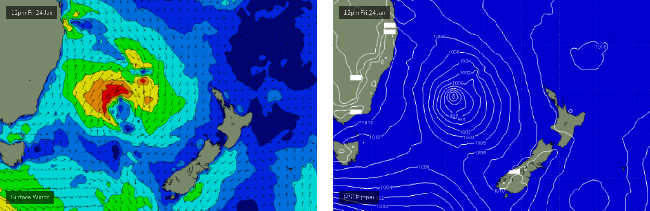
These two factors are working in tandem with a short fetch length (relative to Southern NSW) to really tip the balance away from our region for Saturday. Surf conditions should improve rapidly, as the eastward-tracking low will rapidly ease the pressure gradient and thus the local winds - which should therefore steer offshore for the morning session - but exposed spots will retain some initial lumpiness.
I’m going to keep wave height estimates around 2-3ft at most south facing beaches (smaller elsewhere) but with a little more size (maybe 3-4ft) across the Hunter thanks to the slightly longer fetch length. But don’t get your hopes up for anything amazing. Afternoon sea breezes will develop from the NE too, so early will be best. A slight easing of size should occur into the afternoon.
On Sunday we’ll see a small, long range south swell move into the region, generated by polar low activity well south of the continent earlier in the week.
I suspect it’ll be pretty slow going at dawn but most south facing beaches should see inconsistent 2-3ft sets by lunchtime and into the afternoon, with a few bigger waves across the Hunter and at other reliable south swell magnets. However, beaches not open to the south will be much smaller.
And just another reminder - there will be extremely long breaks between the sets, as this swell will have originated from a very long distance away. Model guidance isn’t keen on it too, so keep your expectations a little lower than normal.
Sunday’s conditions look good with light morning winds and weak afternoon sea breezes.
Next week (27 onwards)
A sequence of poorly aligned fronts south of Tasmania today and over the weekend will send a few glancing south swells across Southern NSW next week, but I’m not very confident about there being much size.
The best looking system of them all is due to arrive late Monday and hold into Tuesday morning, but I suspect we’ll be lucky to see rare 2-3ft sets at a handful of the region’s more reliable south swell magnets. Most other breaks will likely see very little size at all.
A slightly more reliable swell source - even if the wave quality won’t be very high - will be locally freshening NE winds adjacent the coast on Monday afternoon that should whip up a late pulse of NE windswell, persisting into Tuesday with peaky 2ft+ sets.
The only glimmer of hope in this scenario is that the models strengthen the fetch a little over the weekend, and that a southerly change currently modeled for late Tuesday afternoon gets pushed forward a touch, to allow for an afternoon session of fun peaky beaches across southern ends. But that’s probably a little overly optimist for the moment.
Southerly winds trailing the change should whip up some average windswell for Wednesday, however a deep Southern Ocean low associated with this pattern (below Tasmania on Tuesday) should generate a stronger south swell for Thursday. Again, the fetch looks to be poorly aimed for our region but I think we could see a little more size at south swell magnets, maybe up to 3-4ft across the Hunter and smaller elsewhere, but we’ll have to take a closer look on Monday.
Otherwise, Tuesday’s southerly change looks like it may stall off the Mid North Coast in a troughy configuration, the upside of which may be a close range SE fetch generating local swells for Wednesday and Thursday. These may end up being the dominant swell source for the second half of the week.
The super long range outlook has some developing tropical activity in the Northern Coral Sea that may eventually bear some fruit for the East Coast, but probably not for another week or more (i.e. well into the first week of February) - and maybe only for northern regions.
More on that in Monday’s notes.