Better options towards the end of the week after a poor start
Sydney Hunter Illawarra Surf Forecast by Steve Shearer (issued Mon Oct 11 )
Forecast Summary (tl;dr)
- Onshore winds and small S/SSE swell Tues, easing Wed
- NE windswell building Thurs, peaking Fri morning with winds tending offshore
- Small S swell Sat PM with offshore winds
- Larger S swell Sun, holding Mon with improving winds
- Reinforcing S swell Tues, easing through the day
- More NE windswell potential from mid next week. Stay tuned for revisions
Recap
A fairly crap-tacular weekend for surf, with just a small window of clean conditions Sat morning allowing for some leftover S swell to be utilised. Not much size left in it, with 2ft or so at S facing beaches, smaller elsewhere. N’ly winds blew up a small amount of windswell for Sun before the S’ly change hit. Definitely not a weekend to write home about. Today hasn’t improved much, with S’ly winds and short period windswell in the 2-3ft range across most open beaches. Some cleaner babyfood is on offer at more sheltered spots, with protection from the S to SE’ly winds and much smaller size.
 This week (Oct 11-15)
A front brought another vigorous S’ly change through yesterday and a trough, just in advance of the front is now moving northwards, with a small low pressure system expected to form off the North Coast, near the QLD border overnight or early tomorrow.
The interplay between the northwards moving trough and a high pressure system in the Bight, moving E and expected to be located in the Tasman, East of Tasmania through tomorrow and for most of the week, is producing an onshore flow and poor quality surf for most of the region.
Unfortunately that onshore flow and poor quality surf lingers through the first half of the working week, with SE to E winds tomorrow and a mix of short/mid period S swells and even shorter period local windswell making a mess of things. Expect a messy 2-3ft surf tomorrow with SE to E winds and no quality on offer.
Wednesday looks no better with a continuing mix of poor quality swell trains in the 2ft range and E winds, which will tend NE in the a’noon and freshen.
The second half of the week looks a little more interesting. An approaching mid-latitude low in the Bight tightens the the pressure gradient along the western flank of the high in the Tasman, with an increase in N to NE winds off NSW coast. It’s quite a chunky, broad fetch, favouring Central and Southern NSW.
That fetch will strong winds from the NNE to NE through Thursday, with developing NE windswell, building into the 3ft range during the a’noon.
Overnight winds Thursday continue to build NE windswell, which should peak Fri morning in the 4ft range at E’ly exposed beaches. Winds rapidly improve as the mid-latitude low approaches Tasmania and winds along the northern flank of the low swing offshore. They should start NW before tending WNW through the day. Surf will ease through the day as the fetch gets quickly shunted eastwards into the Tasman sea, so get in during the morning to get the most size.
This weekend (Oct 16-17)
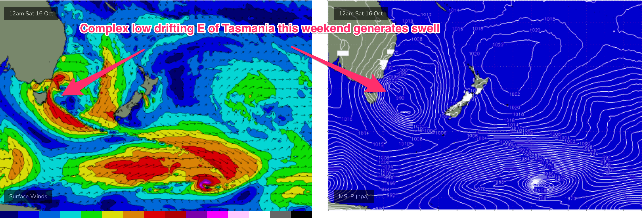
The weekend is all about the low pressure system which drifts E of Tasmania early Sat morning.
There’s still some considerable model divergence surrounding the evolution of the low over the weekend but the basic pattern can be outlined, with revisions on Wed/Fri.
Gales surround the low Sat, possibly pushing out of Bass Strait and developing on the western flank of the low. The outflow from the low and a cold front is likely to see W’ly winds through most of Sat, ironing out the surf to tiny levels. A late kick in S swell is on the cards, with a small pulse from the Bass Strait source seeing surf build into the 2-3ft range later in the day.
Sunday sees solid S swell from the Tasman low with a building trend likely during the day. Expect mid-period surf from the S in the 4ft range at S facing beaches, bigger 4-5ft on the Hunter, to build into the 6ft range during the day, as period thickens up. Some solid 6-8ft surf is likely on the Hunter but winds will be a problem. A high pressure ridge quickly builds in during Sun, with early SW winds, tending S then SE during the day. There’ll be enough size to find waves in sheltered spots but you’ll sacrifice size in doing so.

Next week (Oct 18) and beyond
Plenty of S swell on offer to start next week, under current modelling. The low will be tracking towards New Zealand by Mon morning, with S swell in the 6ft range at S facing beaches and rapidly improving conditions as high pressure drifts across interior NSW to be edging into the Tasman by Monday. That should see light land seabreezes next Mon and good to great conditions.
Easing S swell then is expected from that source with some reinforcing S swell likely Tuesday from frontal activity passing below Tasmania on the weekend. Winds should tend back to the onshore as high pressure in the Tasman directs a weak, onshore flow.
Longer term and N’lies look likely to set up again from mid next week, with another round of potential NE windswell towards the latter half go next week, though models don’t currently have much in the way of windspeeds off the coast.
The current mobile, troughy pattern suggests we’ll be revising this outlook again Wed and Fri so check back then for a full update.


Comments
Hhmmmmm, early next week. That timing might just work out rather nicely.