Solid swell for the weekend
Sydney Hunter Illawarra Surf Forecast by James Casey (issued Wednesday 16th June)
Best Days: Solid S swell over the weekend, reinforcing SE swell for Monday
Outlook (tl;dr)
- Tomorrow (Thursday) morning will see a new S/SE swell arrive in the 2ft+ mark as well as a weak NE windswell from infeed of northerlies overnight
- Moderate S swell for Friday before a solid run of swell starts on Saturday
- Solid S swell for the weekend reaching a peak on Saturday morning up around 8-10ft mark. Unfortunately it comes with strong SW winds so southern corners will be the pick.
- Sunday will still be solid up around 6-8ft early but with SW winds
- Reinforcement of SE swell on Monday with waves up around 5-6ft easing into Tuesday before the swells returns back to smaller 2-3ft waves for Wednesday
Recap
We had an inconsistent mix of E and S swells gave us 2ft waves yesterday in Sydney, a little bigger for the Hunter with the occasional 2-3ft set. Winds were light and offshore for the entire day so conditions were clean.
Today waves are even smaller. It’s 1-1.5 ft in Sydney and the Illawara and 2ft for the Hunter. Winds are light and offshore but there just isn’t much in the way of waves. Bigger boards are necessary for a bit of glide.
The rest of this week
A little S/SE swell should show up tomorrow morning, keep an eye out for a bit of a rise late this evening. This new S/SE swell will provide a bit more energy in the water with waves to reach the 2ft+ mark thanks to strong S/SE winds below NZ earlier in the week with the southwestern flank of a low.
Winds will be stronger and N to NE overnight, there could be a little NE windswell but I wouldn’t expect much from it. Any bump will be ironed out with strong offshore winds along the northwestern edge of a Tasman low keeping conditions clean.
Friday will see a bit of S swell beginning to fill in thanks to the poorly aimed northwestern flank of the low.
Winds will be a bit lighter and more W/NW in the morning but become stronger in the afternoon with a bit more W/SW in it. I’d be saving myself for the weekend of waves though. 
The weekend
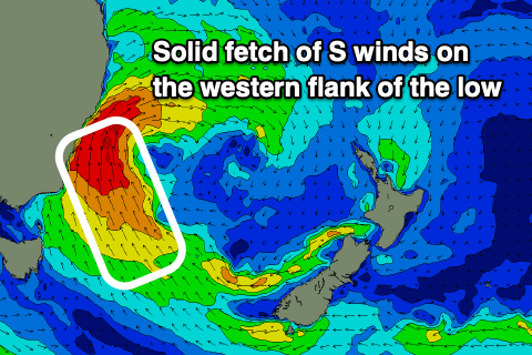
The progression of the Tasman low has been brought forward with the southwestern flank of the low really coming to life Friday afternoon and directing a better aimed S/SE swell for the start of the weekend.
At this stage it’s looking like the swell will peak Saturday morning up around the 8-10ft mark with larger waves at deep water reefs. This is thanks to a strengthening and broadening gale-force S/SE winds surfing up the coast during Friday afternoon and evening.
Winds will continue to be gusty with most spots having SW winds but some being more W/SW early. Even those spots will tend more SW in the late morning. With the strength of these winds you’ll need to stick to the more protected spots that won’t be getting all of the swell but there should still be a bit of size on offer.
Sunday will see the swell begin to ease but it’ll still be up around 6-8ft early but easing into the afternoon. Winds will be a bit lighter but still SW for most of the day keeping the cleanest conditions in the protected southern corners.
Further ahead
On Monday we will see a pulse of SE swell keeping wave heights up around the 5-6ft mark. Ths pulse will come from a strong fetch of winds to the west of NZ’s South Island as a ridge squeezes the isobars of the low.
Winds will continue out of the S/SW for most of the day, again keeping the cleanest conditions to the southern corners.
The swell will ease to around 4ft+ by Tuesday as the run of swell slowly starts to ease into Tuesday afternoon. Winds will be fresh out of the SW early but ease and shift more S in the afternoon.
By Wednesday things look to have eased back to the more palatable 2-3ft waves. While smaller there should be more options on offer for the end of the week.
The longer term outlook is looking promising as mid latitude lows continue to meander in from the west providing plenty of volatile weather and swell potential for us further ahead.

Comments
Hi James.
What size should the waves be Friday morning with the "Moderate S swell".
Thanks
HI Jay,
At this stage it's looking like 3-4ft at the most for magnets while most spots will be more like 2-3ft. The swell will be mainly S/SW so the bulk of it will be moving past our coast. The Hunter will fair a bit better than Sydney and the Illawarra. Hope that clarifies it a bit better for you.
The forecast for the the weekend hasn’t changed much ( no downgrade) looking very powerful and promising..
It's only upgraded!