Solid swell into the weekend
Sydney Hunter Illawarra Surf Forecast by James Casey (issued Monday 3rd May)
Best Days: Thursday until Sunday Outlook:
- Tuesday building NE windswell
- Wednesday will see the start of an easterly trough low form off the east coast and provide plenty of swell out of the E/NE from Thursday until Sunday
- Next week the E trade swell will keep waves up around the 2-3ft mark
Recap
Waves were small but surfable in that 1-2ft range over the weekend, a little bigger on Saturday then Sunday. Winds were light and offshore each morning while a light onshore breeze built into a NE breeze in the afternoon.
Today waves are a little bigger than yesterday as a weak NE windswell starts to fill in, still small though. Winds are light with some fog around for the Hunter.
This week
This morning's light offshores will swing around to the NE later in the day and strengthen. The E/NE swell will continue to build as an established trade swell setup to the north of NZ delivers small waves. While not perfectly aimed for our region we will still see waves peak at 2-3ft on Tuesday.
Tuesday (tomorrow) we will see a change in the weather as an easterly trough low begins to form. Expect less blue skies and more showers.
Winds will be offshore for the Hunter and Sydney early but will swing SW mid morning. The Illawarra will have SW winds from the early morning. With the leftover NE windswell there should be some nice 2-3ft waves with nice conditions at north facing beaches, picking up the most of the swell on offer and being groomed by the SW winds.
Into the weekend
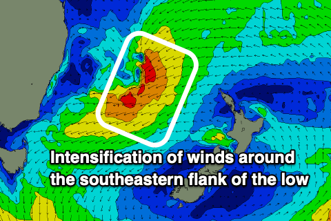
The region of low pressure will intensify as the day goes on on Wednesday with an easterly trough low forming by the evening. Winds will remain more out of the S/SW for the Hunter and Sydney but have more S/SE winds for the Illawarra and further south. The surf will remain in that 2-3ft range as strong S winds whip up some windswell but expect larger stuff in the coming days as the low pinches the strong ridge in the Tasman, causing an intensification of winds around the southeastern flank of the low. 
Thursday will see a larger, mid period E/NE swell to fill in thanks to persistent strong winds on the southeastern flank of the low. Starting off small, wave height will build throughout the day finishing up around the 6ft+ mark by late afternoon, biggest for the Illawarra closer to 6-8ft+. Winds will be out of the S/SW for most of the day, more SW in the morning and more S in the late afternoon.
The low will start shifting south and east on Friday into Saturday. The strongest winds will have already created the largest of the swell though as we see the swell peak up around the 6-8ft+ mark in the morning on Friday before slowing down a little into the afternoon before it peaks again on Saturday morning up around the 6-8ft+ mark, again biggest for the Illawarra around the 8-10ft+ mark. Winds will be offshore on Friday tending light and NE in the afternoon. Saturday will see winds offshore again in the morning tending light and variable in the afternoon.
By Sunday the low will have moved away from the coast and weakened. The swell won’t just disappear though with 3-5ft sets in the morning easing to 3-4ft by the afternoon. With light and variable winds all day expect decent waves to continue across the region.
Next week
Once the swell from the low dissipates an E/NE swell from the trade swell setup will ensure waves stay up around the 3ft mark.
A south change looks to move through early on Monday restricting things to southern corners but with the E/NE swell getting in at most spots there’ll still be decent waves on offer.
Check back in on Wednesday for an update.

Comments
Saturday morning looking real good, hopefully it's big enough to scare off the crowds.
Real swell in the water late. Solid sets every 10min or so and small otherwise. Looked more SE than NE