Small windows of opportunity with a wide range of minor swells
Sydney, Hunter and Illawarra Surf Forecast by Ben Matson (issued Monday 10th September)
Best Days: Tues: early window of light winds, easing S'ly swell. Wed: small mix of swells, chance for a window of light winds into the arvo (better chance further south). Sun: strong south swell.
Recap: Saturday saw deteriorating surf conditions with gusty southerly winds and a peaky mix of swells on the water. Much better surf occurred Sunday as winds went offshore, and a distant E’ly groundswell provided clean 2ft+ sets to open beaches and this energy has persisted through today. This afternoon we’ve also seen a new S’ly groundswell push through earlier than expected (Friday’s notes mentioned Tuesday), originating from a strong frontal passage below Tasmania yesterday. Set waves are now a strong 3ft+ at south facing beaches.

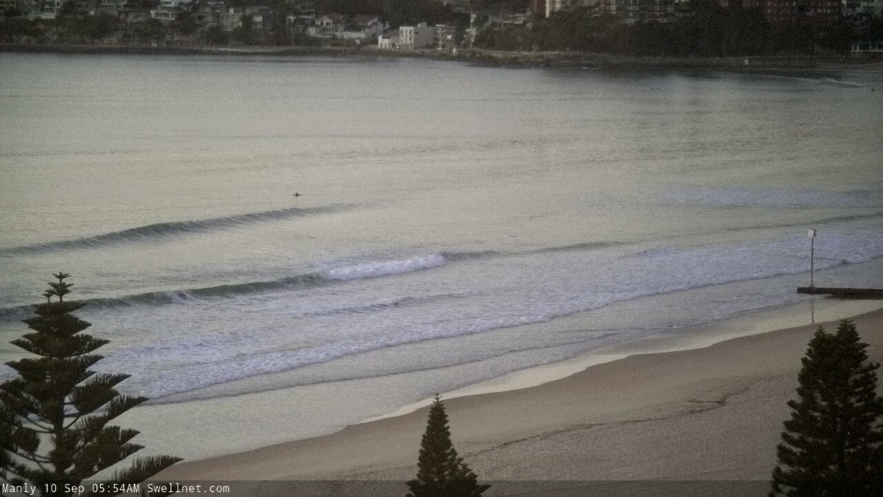
Small residual E'ly swell at Manly this morning
This week (Sep 11 - 14)
Today’s Forecaster Notes are brought to you by Rip Curl
I didn’t get a chance over the weekend to follow the model upgrades for the south swell, which is now pushing into the coast much earlier than expected thanks to the responsible front pushing much further north through the lower Tasman Sea than Friday’s models anticipated.
This swell is reaching a peak now and will trend down into Tuesday. Unfortunately, the synoptic change that brought this initial swell forward has had a negative impact on the short term outlook, as it’s steered some of the trailing systems away from our swell window.
We’ll still see a combo of easing S’ly swell through Tuesday and some small long period energy (15-16 seconds) from a polar low below SA over the weekend, but it won’t contribute much size - perhaps some stray 2-3ft sets at south facing beaches early morning (slightly bigger in the Hunter, though smaller elsewhere), easing to 1-2ft during the day.
Local conditions look a little ordinary with freshening northerly winds throughout the day, a small window of light NW winds are possible early morning so this will be the best time to surf.
Also in the mix over the next few days will be a small long range E’ly swell generated by a broad E’ly fetch way out SE of Tahiti this time last week. It’s currently producing occasional 2ft sets up and down the East Coast and may contribute the odd lil' wave across Southern NSW, though smaller in size with increasing southerly latitude south from Sydney.
Wednesday is a tricky day to have confidence in. The front responsible for today’s south swell is expected to form a secondary low pressure centre off New Zealand’s West Coast today, at about South Coast (NSW) latitudes, before a front slingshots around the low and produces a nice SE swell for Northern NSW.
Raw model guidance doesn’t suggest we’ll see anything south from Seal Rocks, but it’s hard to ignore these small little captured fetches as they often perform better than the models expect. As such I’m going to go out on a limb and call occasional 2ft+ sets from Sydney to the Hunter coasts, with smaller surf south from the Illawarra.
And just for good measure, Wednesday should have some peaky NE swell in the water from the local fetch. Max sets should be running around 2-3ft if we’re lucky.
Wednesday look dicey on the surface though, with freshening northerly winds as a trough approaches from the south. This change probably won’t influence our region tunnel the mid-afternoon, though periods of variable winds are possible around this time and into the end of the day (earlier down south). In any case, keep your expectations low.
The rest of the week looks pretty average with the Southern Ocean storm track too zonal to benefit our coast with anything major in the surf department. Conditions look variable under a troughy pattern too so I don’t think it’s worth getting too excited about surf prospects to finish the week, with small weak peaky waves at most open beaches.
This weekend (Sep 15 - 16)
Saturday looks pretty average with small residual swells from a couple of sources, that are unlikely to provide any great surfing opportunities across the region.
Sunday is shaping up to be the pick of the period, with a powerful front and low passing over Tasmania on Saturday, generating a strong new south swell that should run around the 3-4ft mark at south facing beaches through Sunday (bigger in the Hunter, smaller at beaches not open to the south). I'll firm up the specifics in more detail on Wednesday.
Next week (Sep 17 onwards)
There’s nothing to pin down precisely at this stage, but the broad overview suggests a redeveloping trade flow through the Northern Tasman and South Pacific that could give rise to an extended period of E/NE swells through the second half of next week. More on this in Wednesday’s update.


Comments
need something big soon before my hair starts to fall out
Too late!
Saw the e/ne swell potential on yesterdays chart scan but nothing was showing on the Narooma automated model. But bingo and today it is showing nicely :-)