Average weekend of wind and developing surf, improving from Tuesday
Sydney, Hunter and Illawarra Surf Forecast by Craig Brokensha (issued Friday 11th May)
Best Days: Keen surfers protected spots late Saturday through Monday morning, Tuesday morning, Wednesday morning
Recap
A great mix of easing S'ly groundswell and new E'ly swell yesterday coming in at a clean 3ft through the morning, with temporary sea breezes and then a late return to offshores as the size dropped.
This morning at dawn there were fun 2ft leftovers on the coast, but a stiff offshore has killed off the surf into the afternoon.
Today’s Forecaster Notes are brought to you by Rip Curl
This weekend and next week (May 12 – 18)
These notes will be brief as Ben’s on holidays.
What a tricky forecast period to be thrown into!
Right now we've got a vigorous cold outbreak across the south-east of the country bringing strong winds, torrential rain, and snow through Victoria, NSW and Tasmania.
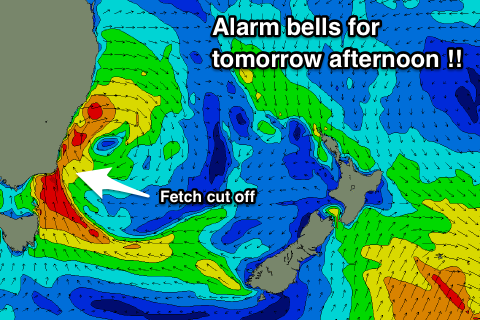
 The models have been shifting around the location of the axis of this Tasman Low once it moves into the Tasman Sea, and this is crucial as the low needs to be far enough offshore for a decent fetch to develop. However, it now appears the low will teeter on the coast, initially forming too far west and cut in half by the Gippsland coast (see image).
Because of this, keep your expectations low for the weekend as we'll be dealing with windy acute Southerly swell which never performs well in the Sydney region.
Firstly tomorrow morning is likely to be tiny to flat, with strong offshore winds overnight and no favourable wind in our swell window. However, this afternoon the first fetch will develop off Tassie's north-east coast pointed north towards the East Coast.
Although narrow, this fetch will be significant with gale force S/SE winds overnight expected to drive north while tending more Southerly but then being slightly cut off and weakening just south of Sydney (gale-force from the S/SW-SW in the Hunter).
This will result in a large spike in Southerly groundswell with step-ladder sets through the afternoon as south facing beaches go from almost flat to large and dangerous by dusk.
If this fetch wasn't slightly cut-off by the Gippsland Coast I'd expect south facing beaches to easily reach 8-10ft, but the slicing in half of the fetch has me sceptical and we may only see sets pushing 6 to maybe 8ft and that's late afternoon.
So expect the morning to be clean though flat, with a significant increase in size through the afternoon along with strong Westerly tending gale-force SW winds. With the acute south angle, spots picking up the size will be very wind affected into the afternoon, while open beaches cleaner but much much smaller.
Saturday's late spike in swell is expected to ease back into Sunday, but some good S/SE groundswell will be in the mix from the fetch of S/SE gales off the Tassie Coast.
South magnets should see 6ft to possibly 8ft waves, easing through the day as the low weakens and starts drifting east into the Tasman Sea. Strong S/SW winds (possibly SW early in areas) will limit surfing options, especially with the acute south angle.
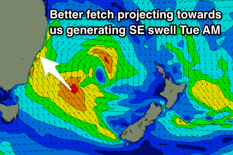
A strong fetch of S/SE winds will be projected up towards us on top an active sea state, possibly producing late pulse of S/SE swell on dark, but Monday is better chance to see this. South facing beaches look to come in at 6-8ft Monday morning, with a bit more size showing at open beaches with the extra touch of east in the swell. Winds look poor though and generally fresh and gusty from the S/SW-S leaving very limited options.
 Everything starts to take a turn for the better on Tuesday when we'll see better winds and a good pulse of SE swell.
The SE swell that may be seen later Monday but is better Tuesday coming in at a great 5-6ft+ through the morning with a SW offshore, W/SW across select locations.
This should be generated by a great fetch of SE winds slingshotting up towards us Sunday evening, on top an active sea state.
In the wake of this fetch weaker but persistent SE winds will be aimed towards us through Monday morning before shifting more south and away from us into the evening.
This will soften the easing trend through the afternoon and Wednesday. We may see a small short-wave feature pushing up the coast Wednesday bringing average S/SW-SE winds, but we'll have a closer look at this Monday. Have a great weekend and keep your expectations low.


Comments
:(
My thoughts as well. If the low just shift a little more east it could be game on though. But latest updates this afternoon still have a disjointed fetch.
Wax up the Balsa Gun Craig...!
I'm hearing "South Steyne Flags Will be on From Sat Arvo to Forever."
You wish Andy!
Again another disappointment even thou I cant surf giant waves anymore
I still get excited when they are mentioned then boom taken away again.
It has been a very very bad year so far for surf this year in the Sydney area. Thank goodness for Hawaii and Bali otherwise I think I would of gone mad.
It’s gonna get big!!
Did Chopes pump out of interest?
The Teahupoo swell is due Saturday, which is our Sunday.
On target this morning in Sydney and flat.
Yea!h disappointing so far, see what eventuates when I'm back at work & the low is in the central Tasman!
Not disappointing, on track and as expected :)
Craig/Ben random question for you. What is the usual arrival time distance fir a south swell like this between the buoys from Batemans through to Sydney. Watching the spikes and the timing would be useful
Speed = 2.81* period, so a 10s swell travels at 28km/h and 16s swell 45km/h.
Thanks
Stepladder sets in full affect when I surfed. Was 2-3ft then quickly jumped to 4-5ft sets in an hour with the odd 6ft bomb but kinda plateaued a bit.
Reports south magnets kicked to 6ft+ on dark. Played out to forecast so far.
2.81, thanks Craig, the magic number.
Looking at the fetch chart, I wonder how that controversial boat ramp on the Mexican side of southern NSW fared with that blasting into it?
20 sec swell = 56.2 km/h ?
Could it be excactly double the speed of 10sec swell..?
Pretty underwhelming Kiama and surrounds. Four feet @ best.
Yeah right where the fetch kinda split in half. So not great at all. Tuesday..
Another HOAX not your guys fault but hell its frustrating. I just need to rant.
Um...yesterday arvo turned on and pumped. A few spots looked awful but a few breaks with enough wind protection were pretty good.
Spot on forecast for the weekend Craig. It was really educational reading these notes, and learning how the cut off low affects swell creation. Would I be correct in saying that wind direction, speed, and fetch determine a location's pumping-ness? (Or is it pumpability? )
I have long wondered how fast does a wave travels so thanks for that equation. Seems legit and saves me googleing it.
I think the Daily Surf Report is consistently accurate. The three (Free) daily photos are always excellent. If you are ever going to paywall something, imho do the notes only and leave the surf report free.
Thanks mate, and I guess a lot of things come into if a spot is going to pump. Some spots love long period energy, others not, some winds from a certain direction, others not and so on..
Looking at the latest model updates the strong SE pulse will likely show late today and peak overnight.
Mid-late morning some stronger 4-5ft sets were pushing through North Steyne/Queensy.
Some easy 6ft plus sets this afternoon at my neck of the woods.
Finally something happened Yippee and Yahoo
Yeah same here, that SE pulse! Easing tomorrow but nice and clean, bring it on!