Plenty of swell from the south and east
Sydney, Hunter and Illawarra Surf Forecast by Craig Brokensha (issued Monday 5th February)
Best Days: Tuesday morning, Wednesday morning, early Thursday morning, Saturday morning, Sunday
Recap
Early windows of clean conditions across the region over the weekend with a mix of easing E/NE and S/SE swells to 3-4ft on Saturday and 3ft Sunday.
This morning conditions were excellent with a crisp cool offshore wind and 2ft+ of E'ly swell mixed in with 2ft to occasionally 3ft of S'ly swell.
Today’s Forecaster Notes are brought to you by Rip Curl
This week and weekend (Feb 6 – 11)
These notes will be brief-ish as Ben’s away today.
Our fun week of waves is still on the cards, with a distant and very inconsistent E'ly groundswell that was evident in the water this morning expected to build further through this afternoon/evening and reach 3ft on the sets, peaking tomorrow morning in the 3ft+ range.
 This swell was generated last week, east-northeast of New Zealand by a tropical low.
Due to the large distance between the swell source and us, we'll see long waits between sets.
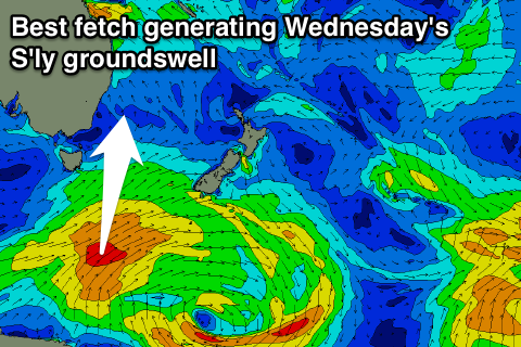
Also in the mix will be a more consistent and building S'ly groundswell, with a secondary pulse for Wednesday morning.
These swells have been generated by a good broad and slow moving polar frontal progression that's produced a fetch of strong to gale-force SW winds from south of Tasmania, up towards New Zealand.
We should see south swell magnets building to 3-4ft tomorrow afternoon with the initial pulse, while Wednesday morning is likely to reveal sets to 5ft at these locations. In general we're looking at surf to 3-5ft, easing through the afternoon, down from 3ft on the sets, smaller into the afternoon.
One final pulse of sneaky and inconsistent S/SE groundswell is due Friday afternoon and Saturday morning, generated by a tight polar fetch of gale to severe-gale S/SE winds on the backside of the progression generating the mid-week swell.
Infrequent 2ft to occasionally 3ft sets are likely to be seen at south magnets, fading later in the day and smaller Sunday.
Coming back to local winds, and tomorrow we should see clean conditions with a light variable W/NW breeze ahead of weak E/NE afternoon sea breezes, N/NW tending fresh E/NE winds on Wednesday and fresh NE winds Thursday/Friday, lighter and more N'ly early.
With this NE winds there’ll be some small weak NE windswell also in the mix.
 Saturday morning should see lighter N/NW breezes ahead of a fresh NE sea breeze.
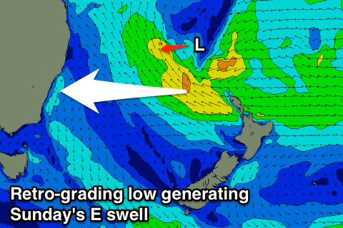
Now, as the S/SE swell starts to ease Saturday afternoon, some new E'ly swell should start building, peaking through Sunday.
The source of this swell will be a broad tropical low drifting slowly south towards New Zealand as a strong supporting high sits over New Zealand.
Initially a strengthening fetch of E/SE trades will be cut in half by the North Island, but we're expected to see the low retro-grade west towards us later this week before the system falls apart in the Tasman Sea on Saturday.
This should generate a fun sized E'ly swell that's expected to build Saturday afternoon, reaching 2-3ft by dark ahead of a peak Saturday in the 4ft+ range. Winds are looking favourable early with light morning offshores ahead of a gusty S/SE change through the morning, but we'll review this Wednesday.


Comments
Fun and inconsistent in the same sentence?
Setting expectation low as this summer and the reports have Kevin Spaceyed us all. Heard Moroubra has been great though...
The summer can be measured in halves. Here’s the swell that turned the tap on. This was a solo session :)
Just tried to fix for you but ended up screen shotting the photo and posting that. Epic shot!
Jeez photobucket is clunky and shit. Couldn't even source a URL for your photo without it loading in photobuckets webpage.
Hey Ben has the fact that Capetown is running out of water & that our South swell window seemed to have shut down this summer got anything to do with each other? Cheers !
South Africa’s water problem isn’t a brief seasonal interlude, it’s a long term trend. Fascinating from a scientific point of view though the social impacts are staggering.. and this isn’t the last we’ll hear of these kinds of problems around the world either.
So no, nothing to do with swell.
was solid 4 ft south of sydney. wonder if itll be bigger than that again tomorrow
South swell?
definitely bigger than yesterday. ill go out on a limb and say i saw a 6ft bomb or 2 but it wasn't where i surfed. was prob 4 ft with a few rogue 5 footers cleaning out the lineup.
Both I think.
Well down on size at Maroubra this morning, 2ft at best and was small last night also, 2ft again.
Good 3-4ft sets at south swell magnets..
Bah, now Im having FOMO as I sit in traffic on the bus to work. Hope everyone scores