Small flukey swells to continue for some time

Sydney, Hunter and Illawarra Surf Forecast by Ben Matson (issued Friday 5th January)
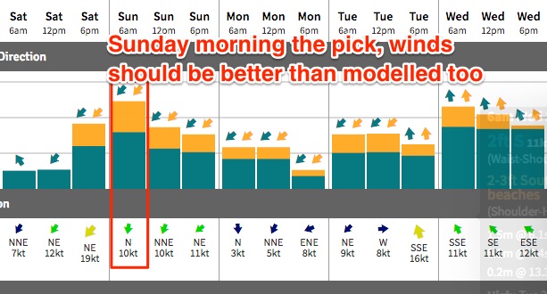
Best Days: Sun AM: early light winds and a peaky NE swell. Wed/Thurs: mainly onshore, but with a mix of S'ly tending E'ly swells.
Recap: Small easing S’ly swells Thursday delivered a few 2ft+ sets at reliable swell magnets before easing throughout the day. Surf size has bottomed out around 1ft+ today.
Today’s Forecaster Notes are brought to you by Rip Curl
This weekend (Jan 6th - 7th)
We’re starting off with an almost blank canvas on Saturday morning, due to a current lack of regional swells.
Freshening NE winds will however whip up some local windswell throughout the day, towards a peak on Sunday morning in the 2-3ft range at NE facing beaches. Expect smaller surf at south facing beaches, and through the northern Hunter.
Fortunately, a low pressure trough crossing the coast in the morning will swing the winds around to the NW, albeit light in strength (so, perhaps not enough to completely iron out the northerly wobble). Still, conditions will certainly be on the improve.
A shallow southerly change will push up the coast into the afternoon, probably reaching Sydney around dinnertime - but by and large most coasts should see OK conditions through the morning. In fact, NE winds may briefly redevelop through the middle of the day ahead of the change, though I don’t think there’ll be much strength and they should slacken off for a few hours just prior to the arrival of the southerly.
Some small long period S'ly swell may also be present in the water on Sunday, from a system that traversed the waters south of Tasmania earlier this week. I am not expecting much from this though.
As a side note, I’ve been discussing a complex, interesting low all week that developed off New Zealand’s West Coast yesterday. ASCAT satellite data is now in and whilst one swathe showed a small region of strong E’ly winds in our swell window (last night), some 12 hours later (this morning) it was all but gone. This very short duration is not a favourable outcome for swell production, despite the strength of the fetch.
The models had a brief SE swell arriving Sunday afternoon in this morning’s runs, but they’ve wiped it off in the latest update (pushing it back to Monday afternoon, sourced from a secondary fetch - and just 0.2m @ 9 seconds).
Either way, I don’t hold much confidence for any SE swell to arrive on Sunday, but theoretically it is possible we may see a few minor lines of energy at exposed beaches. Don’t hold your breath.
Next week (Jan 8th onwards)
We've had another round of model changes for next week. But the short story still remains rather unfavourable for Southern NSW surfers.
Essentially, the broadscale storm track is aligned away from our coast so we’ll continue to see minor pulses of energy glancing the coast from poorly positioned Southern Ocean lows (arriving Tuesday and Wednesday), plus some small intermittent NE energy (Monday and Tuesday) from a small fetch located on the northern flank of a slow moving troughy pattern in the south-western Tasman Sea. Neither source will bring very much size though.
A small front will clip the coast later Tuesday and a moderate S/SW fetch associated with the parent system to the south may generate a brief flush of southerly swell for Wednesday, though onshore winds are modelled to create average conditions. A ridge building through the Central Tasman Sea on Wednesday should build local short range E’ly swell into the afternoon and Thursday though no great size or quality is expected.
As such, the wait for good surf continues. Hang in there!