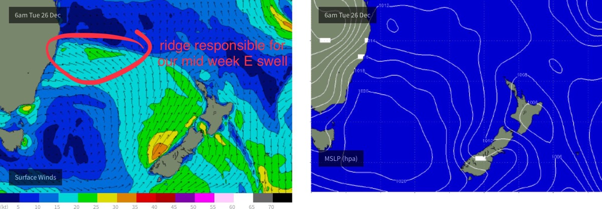
Small mid week east swell for the open beaches
Sydney, Hunter and Illawarra Surf Forecast by Ben Matson (issued Monday 25th December)
Best Days: Tues/Wed/Thurs: peaky east swell, bumpy but workable. Sat: peaky NE swell, easing with light winds.
Recap: Friday’s south swells built slightly across most Southern NSW beaches on Saturday, with peaky 2ft+ sets though interestingly, the Hunter coast pulled back marginally. A small east swell was also present. Both swells eased into Sunday. Today we’ve seen gusty SSE winds and a poor quality local windswell.
Today’s Forecaster Notes are brought to you by Rip Curl
This week (Dec 26 - 29)
Not much to see this week - but there’ll be waves, and it’ll improve from today.
A ridge will build through the central Tasman Sea on Tuesday, and whilst or current short range SSE swell will fade, we’ll see a building mid range east swell that’s expected to provide 2-3ft sets at most open beaches through Tuesday and Wednesday, before easing from early Thursday.
Unfortunately, winds will remain onshore throughout the period, slowly swinging anticlockwise - though it’ll be lighter than today. Expect moderate E’ly winds Tuesday, ENE Wednesday, NE Thursday and NNE Friday, of which the second half of the week will also see a gradual freshening trend.
In fact Friday should see the easing E tending ENE swell replaced by a short range NE windswell. Quality won’t be high but and facing beaches should pick up 2-3ft sets by the afternoon.

This weekend (Dec 30 - 31)
A weak trough crossing the coast over the weekend will deliver light variable winds and thus a steady improvement in the surf quality. However, with no new swells on the way you’ll have to make the most of early Saturday which should see leftover 2-3ft peaks at dawn, easing to 1-2ft during the day.
Sunday will then see small residual swells with light variable winds.
Next week (Jan 1st onwards)
There’s nothing of any major interest in the long term forecast at this stage.
A deep low will track south of Tasmania over the weekend but it’ll be poorly aligned within our swell window. We should see some minor long period energy glancing the coast around Tuesday or Wednesday but it’s unlikely to generate any major size for our region.
Elsewhere the synoptics look a little benign. Let’s see how it might appear in Wednesday’s update.

