Strong south swell Sunday; plenty of surf for next week too
Sydney, Hunter and Illawarra Surf Forecast by Ben Matson (issued Friday 29th September)
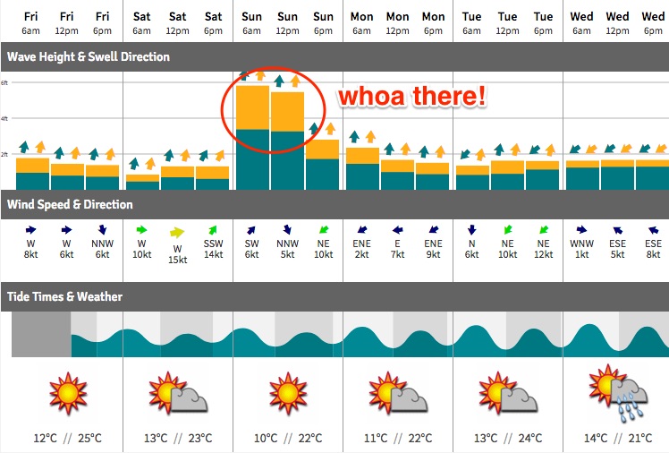
Best Days: Sat: small clean leftovers. Sun: solid S'ly swell with easrly offshores. Mon/Tues/Wed: intermittent small/mod S'ly swell, early light winds. Tues onwards: small building NE swell.
Recap: The expected NE swell produced great 3ft waves about Sydney beaches Thursday, before easing to 1-2ft today. A new long period S’ly swell arrived late Thursday, combining with a secondary mid-period S’ly today to produce fun 2ft+ waves across Sydney’s south facing beaches. Conditions have been clean everywhere both days with offshore winds.

Northern end of the Manly stretch looking nice this morning
This weekend (Sep 30 - Oct 1)
Saturday will see today’s triple swell combo ease back in size.
Conditions will be clean with light to moderate offshore winds, but only south facing beaches will pick up anything rideable, best in the Hunter with maybe some stray 2ft sets (smaller elsewhere, especially beaches not open to the south).
Today's good news is that we’ve had a decent upgrade for Sunday’s south swell, back inline with what I was projecting last Monday. This is mainly related to a strengthening of the front exiting eastern Bass Strait on Saturday morning. Strong southerly energy should fill into the South Coast late Saturday afternoon, but I’m doubtful it’ll arrive soon enough to be of use for surfers north of Wollongong (that being said, a cursory glance of the buoy data and Cronulla cams around 4pm wouldn’t go astray).
This swell should fill into the Sydney region on Saturday evening, and is expected to reach a peak in the early hours of Sunday morning - and with early light offshore winds on hand there’ll be some great waves around for the morning session. South facing beaches should see 4-6ft sets (smaller at most beaches around the 3ft+ mark, smaller again inside southern corners) but the Hunter coast could pick up occasional bigger bombs north of 6ft+.
Surf size will ease throughout the day, more rapidly from mid-afternoon onwards, and we’re looking at moderate NE sea breezes at this time too. So aim for a morning session for the biggest and best waves.

Next week (Oct 2 onwards)
A series of broad secondary fronts trailing the system responsible for Sunday’s pulse will maintain small to moderate levels of south swell through the first half of next week.
No major size is expected, but in general we should see a base level of inconsistent 2-3ft surf at south facing beaches (smaller elsewhere, though bigger in the Hunter) with a couple of embedded pulses pushing into the 3-4ft range (again, bigger in the Hunter, smaller elsewhere). There are two short lived pulses on target right now - one for Tuesday and the other for Wednesday - but confidence is not high on the specific timing. I’ll reevaluate on Monday.
As for conditions, we’re looking at a developing trough across the eastern states during this period, which will freshen NE winds from Monday afternoon onwards. No major strength is expected in the breeze for a few days though, and we should see periods of light variable winds in the early mornings, but nevertheless it’ll be worth keeping these winds in mind as only protected northern corners will be reliably clean throughout this period (fortunately, they’ll also pick up the most size from the south).
The developing trough should bring about a small, slow increase in NE windswell through the first half of the week, probably reaching 2ft at NEW facing beaches by later Tuesday and through Wednesday, with bigger surf on the cards from this source through Thursday and Friday as the fetch strengths in our near swell window. However, model guidance on this pattern has shifted a lot in the last few days though so confidence is not very high.
The only other source of swell for next week is a small but intense polar low that’s modelled to meander off the Antarctic ice shelf immediately south of of New Zealand from Monday onwards. It’s likely that a fair percentage of the fetch will be over ice - so therefore not in a position to produce swell - but we’ll be able to confirm this via ASCAT observations next week. In any case, small, long period S/SE energy is possible Thursday or Friday at south facing beaches, maybe some intermittent 2ft sets if this system is very well behaved. Certainly not worth working around though.
See you Monday!


Comments
Nice options across the Manly stretch this morning. Bummer the swell peaked overnight (over such a short space of time too!) and is already easing. Gotta get in quick this AM!
Plenty of lines at Maroubra this morning too.
That's a decent size for Queenscliff on a straight south swell.