Extended period of small surf, best on Thursday
Sydney, Hunter and Illawarra Surf Forecast by Ben Matson (issued Wednesday 25th January)
There's only one week left to sign up for the P-Pass competition! Sign up to Swellnet’s newsletter and receive the Sydney, Hunter and Illawarra Forecaster Notes and latest news sent directly to your inbox. Upon signup you'll also enter the draw to win a surf trip to P-Pass for you and a mate. It doesn’t get much easier so click HERE to sign up now.
Best Days: Nothing great but there'll be small waves most days, Thursday is the pick with a peaky combo of south swells and early light winds.
Recap: The model outlook was pretty good for Tuesday, with around 3ft of peaky NE swell (easing during the day) and 2ft+ of leftover S’ly swell. Early N’ly winds swung W/NW ahead of a gusty late S’ly change. So the beaches had fun peaky waves through the middle of the day. Today's surf has become dominant from the south, thanks to a decent fetch trailing yesterday’s change. South facing beaches have seen peaky sets in the 3ft range though conditions have been a little wobbly thanks to a leftover, moderating southerly breeze.

Cleaner but easing S'ly swell at Bondi this afternoon
This week (Jan 26th - 27th)
Although the models did pretty well with today’s short period S’ly swell, I reckon they’ve undervalued tomorrow’s S’ly groundswell.
This energy will have originated from the parent low to yesterday’s change, which tracked below Tasmania on Tuesday. The fetch around the low wasn’t ideally positioned but it was very strong and we’ll see a small degree of energy glance the coast during the day. Reliable south swell magnets in Sydney should pick up 2-3ft+ sets (bigger in the Hunter) but most other beaches will be much smaller. Size is expected to peak through the afternoon so don’t be surprised if it’s a little smaller at first light.
The models don’t seem to be interested in a small secondary S/SE swell expected tomorrow either, originating from the weekend’s intensification of a polar low S/SE of New Zealand. No major size was expected anyway but it’ll be interesting to see if we experience bigger sets as the two southerly swells overlap. However sets will be very inconsistent from this source.
Conditions should be pretty good on Thursday with light variable winds and sea breezes.
Easing swells are then expected through Friday, and early light variable winds will eventually give way to freshening NE breeze in the afternoon. At this stage south facing beaches should see a slow mix of southerly swells around the 2ft mark (bigger in the Hunter) but it’s expected to become smaller during the day.
This weekend (Jan 28th - 29th)
Still nothing major expected for the weekend.
Freshening NE winds on Saturday will generate small NE windswells for the region, peaking early Sunday as a weak trough instigates a shallow southerly change. It’s not expected to have much influence on the broader synoptic and in fact the NE fetch may retreat only temporarily off the Mid North Coast, which suggests just a small easing trend throughout the day. NE swell magnets may pick up some 2ft+ sets later Saturday (bumpy under the NE breeze) and early Sunday (clean with early SW winds) but that’s about it.
Otherwise, we may see a small underlying pulse of long range S/SE swell from the much discussed polar fetch S/SE of New Zealand, but again, no major size is expected.
Next week (Jan 30th onwards)
Still nothing of any substance in the long term. The Tasman Sea is expected to remain troughy but relatively benign, and a moderate zonal pattern through the Southern Ocean doesn’t offer much hope for any major energy.
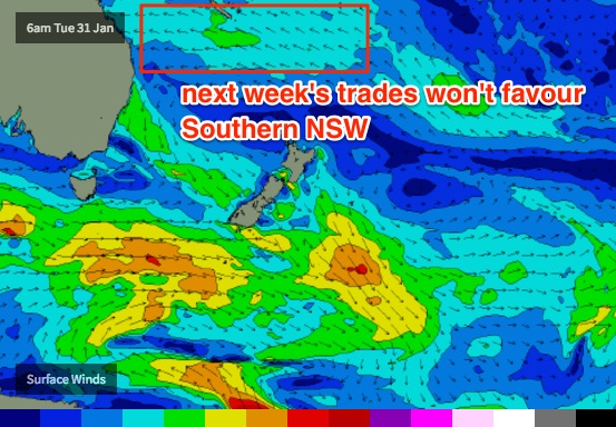
The trades will freshen across the Northern Tasman Sea but this will mainly favour SE Qld and Northern NSW, so there’s really nothing to get excited about for now.
Let’s hope Friday’s updated forecast notes have some better news!


